

Německo 2012-3.den- WeiserMain-Radweg
A cycling route starting in Fichtelberg, Bavaria, Germany.
Overview
About this route
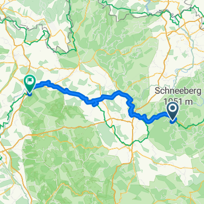
3rd day of the route 26.05.2012, the destination is the confluence of the White and Red Main and then further along Main.<br />
From today, I will be riding the WeiseMainRadweg all the way to Kulmbach. There is the confluence of the White and Red Main.
From here, the route continues under the name Main-Radweg.
Overnight stay at the crossroads Banz-blick, under the Basilica of the Fourteen Saints
With the visit of the town covered: 92km
Source Weiser Main - Bischofsgrün - Bischofsgrüner Granit - Bad Berneck - Lanzendorf - Himmelkron - Neuenmarkt-Wirsberg - Wirsberg - Ludwigschorgast - Untersteinach - Kulmbach - Mainleus - Willmersreuth - Mainklein - Burgkunstadt - Stroessendorf - Hochstadt am Main - Schwürbitz - Michelau in Upper Franconia - Lichtenfels - overnight stay outside the city
- -:--
- Duration
- 91.7 km
- Distance
- 162 m
- Ascent
- 771 m
- Descent
- ---
- Avg. speed
- ---
- Max. altitude

Route quality
Waytypes & surfaces along the route
Waytypes
Path
24.8 km
(27 %)
Track
23.8 km
(26 %)
Surfaces
Paved
60.5 km
(66 %)
Unpaved
17.4 km
(19 %)
Asphalt
59.6 km
(65 %)
Gravel
11.9 km
(13 %)
Route highlights
Points of interest along the route

Photo after 0 km
Ráno, perfektní nocleh, nemusela jsem stavět stan

Photo after 0.7 km
Pramen Main zase bude hezky

Photo after 1.8 km
Weiser Main- tak už malinko větší

Photo after 4.3 km
Lanovka na Ochsenkopf

Photo after 5.8 km
Bischofsgrün - mapa

Photo after 6.1 km
Matthäus-Kirche - Bischofsgrün

Photo after 6.2 km
Parkoviště opravuji kolo

Photo after 8.3 km
A už to hezky frčí z kopce - konečně

Photo after 14.1 km
Trochu změny

Photo after 24.6 km
St. Gallus - Lanzendorf

Photo after 25.5 km
Moderní

Photo after 44.9 km
Kulmbach

Photo after 46.7 km
Mapa

Photo after 47 km
Má pěkné tetování

Photo after 53.2 km
Soutok Bílého a Červeného Mohanu

Photo after 89.2 km
Lichtenfels

Photo after 91.7 km
Zítra prozkoumám !
Continue with Bikemap
Use, edit, or download this cycling route
You would like to ride Německo 2012-3.den- WeiserMain-Radweg or customize it for your own trip? Here is what you can do with this Bikemap route:
Free features
- Save this route as favorite or in collections
- Copy & plan your own version of this route
- Split it into stages to create a multi-day tour
- Sync your route with Garmin or Wahoo
Premium features
Free trial for 3 days, or one-time payment. More about Bikemap Premium.
- Navigate this route on iOS & Android
- Export a GPX / KML file of this route
- Create your custom printout (try it for free)
- Download this route for offline navigation
Discover more Premium features.
Get Bikemap PremiumFrom our community
Other popular routes starting in Fichtelberg
 Fichtelgebirge Gipfeltour
- Distance
- 25.3 km
- Ascent
- 707 m
- Descent
- 707 m
- Location
- Fichtelberg, Bavaria, Germany
 Mainradweg
- Distance
- 548.4 km
- Ascent
- 46 m
- Descent
- 866 m
- Location
- Fichtelberg, Bavaria, Germany
 Kösseine Fichtelgebirge MTB
- Distance
- 59.2 km
- Ascent
- 1,065 m
- Descent
- 1,065 m
- Location
- Fichtelberg, Bavaria, Germany
 mnebike mittel
- Distance
- 38.5 km
- Ascent
- 631 m
- Descent
- 622 m
- Location
- Fichtelberg, Bavaria, Germany
 Schöne Ochsenkopf - SchneebergTour
- Distance
- 30.5 km
- Ascent
- 663 m
- Descent
- 663 m
- Location
- Fichtelberg, Bavaria, Germany
 mnebike2
- Distance
- 42.4 km
- Ascent
- 792 m
- Descent
- 746 m
- Location
- Fichtelberg, Bavaria, Germany
 Německo 2012-3.den- WeiserMain-Radweg
- Distance
- 91.7 km
- Ascent
- 162 m
- Descent
- 771 m
- Location
- Fichtelberg, Bavaria, Germany
 tag_01_fichtelgebirge
- Distance
- 74.5 km
- Ascent
- 689 m
- Descent
- 840 m
- Location
- Fichtelberg, Bavaria, Germany
Open it in the app