

Německo 2012-6.den-Main-Donau-Kanal
A cycling route starting in Freystadt, Bavaria, Germany.
Overview
About this route
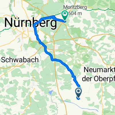
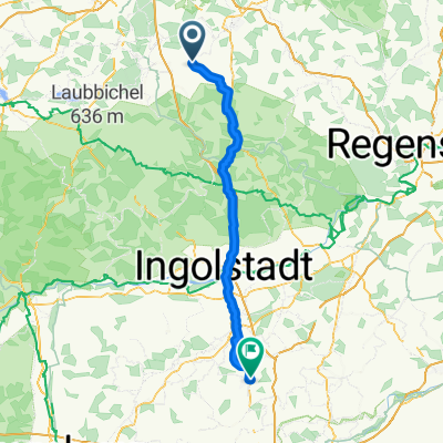
Day 6 of the route on 29.05.2012, still along the Main-Danube Canal towards Regensburg.
Today I'm riding along the canal again. In Berching at the national office, I leave the charger in the socket and go shopping. City tour and visit to the information center. I continue on the left side, but I should have taken the right side, which is better quality. Gradually the valley narrows and there is again much to see. Overnight stay is at the last lock near Kelheim.
Distance covered: 74.5 km
Rabenhof - Bachhausen - Sollngriesbach - Berching - Eglasmühle - Plankstetten - Beilngries - Ottmaring - Dietfurt an der Altmühl - up to Mühlbach - and the valley starts to narrow - Meihern - Riedenburg - Prunn - Essing - Altessing - night at the lock of Kelheim
- -:--
- Duration
- 70.4 km
- Distance
- 54 m
- Ascent
- 124 m
- Descent
- ---
- Avg. speed
- ---
- Max. altitude

Route highlights
Points of interest along the route

Photo after 0 km
5.nocleh přímo u kanálu

Photo after 0.5 km
K naštvání o kousek dál tohle odpočívadlo :-))

Photo after 18.4 km
Berching

Point of interest after 31.3 km

Photo after 31.5 km

Photo after 31.7 km
Ottmaring

Photo after 31.8 km
Odpočívadlo

Photo after 35.5 km
Město kašen

Photo after 42.4 km
Tak tam neee - Flügelfelsen

Photo after 43.4 km
Louky

Photo after 45 km
Nevím

Photo after 46.6 km
Archeologický park Altmühltal

Photo after 51.2 km
Zdymadlo Riedenburg

Photo after 52.8 km
Nahoře Rosenburg

Photo after 58.1 km
Burgweg

Photo after 61.8 km
Lávka přes kanál a nahoře Randeck

Photo after 62.5 km
Randeck

Photo after 66.7 km
6. nocleh u zdymadla Kelheim
Continue with Bikemap
Use, edit, or download this cycling route
You would like to ride Německo 2012-6.den-Main-Donau-Kanal or customize it for your own trip? Here is what you can do with this Bikemap route:
Free features
- Save this route as favorite or in collections
- Copy & plan your own version of this route
- Sync your route with Garmin or Wahoo
Premium features
Free trial for 3 days, or one-time payment. More about Bikemap Premium.
- Navigate this route on iOS & Android
- Export a GPX / KML file of this route
- Create your custom printout (try it for free)
- Download this route for offline navigation
Discover more Premium features.
Get Bikemap PremiumFrom our community
Other popular routes starting in Freystadt
 Von Freystadt bis Leinburg
- Distance
- 53.6 km
- Ascent
- 346 m
- Descent
- 393 m
- Location
- Freystadt, Bavaria, Germany
 Von Freystadt bis Nürnberg
- Distance
- 40.4 km
- Ascent
- 265 m
- Descent
- 363 m
- Location
- Freystadt, Bavaria, Germany
 Davi Rennbahn
- Distance
- 7.3 km
- Ascent
- 157 m
- Descent
- 159 m
- Location
- Freystadt, Bavaria, Germany
 Route in Freystadt
- Distance
- 56.7 km
- Ascent
- 391 m
- Descent
- 395 m
- Location
- Freystadt, Bavaria, Germany
 Am Keller nach Am Keller
- Distance
- 30.7 km
- Ascent
- 200 m
- Descent
- 200 m
- Location
- Freystadt, Bavaria, Germany
 Německo 2012-6.den-Main-Donau-Kanal
- Distance
- 70.4 km
- Ascent
- 54 m
- Descent
- 124 m
- Location
- Freystadt, Bavaria, Germany
 Mühlhausen - Pfaffenhofen an der Ilm
- Distance
- 94.7 km
- Ascent
- 698 m
- Descent
- 683 m
- Location
- Freystadt, Bavaria, Germany
 11.06.02 Freystadt-Nürnberg--Erlangen-Forchheim-Ebermannstadt (4. Etappe)
- Distance
- 108.5 km
- Ascent
- 137 m
- Descent
- 250 m
- Location
- Freystadt, Bavaria, Germany
Open it in the app