

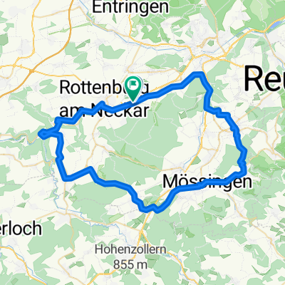
Rottenburg Besigheim
A cycling route starting in Rottenburg, Baden-Württemberg, Germany.
Overview
About this route
- 8 h 4 min
- Duration
- 128.7 km
- Distance
- 607 m
- Ascent
- 775 m
- Descent
- 16 km/h
- Avg. speed
- 347 m
- Avg. speed
Route quality
Waytypes & surfaces along the route
Waytypes
Path
43.4 km
(34 %)
Track
32.1 km
(25 %)
Surfaces
Paved
110.9 km
(86 %)
Unpaved
12.9 km
(10 %)
Asphalt
103.2 km
(80 %)
Gravel
6.7 km
(5 %)
Continue with Bikemap
Use, edit, or download this cycling route
You would like to ride Rottenburg Besigheim or customize it for your own trip? Here is what you can do with this Bikemap route:
Free features
- Save this route as favorite or in collections
- Copy & plan your own version of this route
- Split it into stages to create a multi-day tour
- Sync your route with Garmin or Wahoo
Premium features
Free trial for 3 days, or one-time payment. More about Bikemap Premium.
- Navigate this route on iOS & Android
- Export a GPX / KML file of this route
- Create your custom printout (try it for free)
- Download this route for offline navigation
Discover more Premium features.
Get Bikemap PremiumFrom our community
Other popular routes starting in Rottenburg
 Schönbuch - Weiler Hütte
- Distance
- 50.2 km
- Ascent
- 385 m
- Descent
- 384 m
- Location
- Rottenburg, Baden-Württemberg, Germany
 Wenn ich den See seh, brauch ich kein Meer mehr
- Distance
- 173.5 km
- Ascent
- 960 m
- Descent
- 914 m
- Location
- Rottenburg, Baden-Württemberg, Germany
 Nach Dusslingen und Tübingen
- Distance
- 33.5 km
- Ascent
- 234 m
- Descent
- 234 m
- Location
- Rottenburg, Baden-Württemberg, Germany
 Aiblestraße nach Sinsheimer Straße
- Distance
- 113.1 km
- Ascent
- 974 m
- Descent
- 1,151 m
- Location
- Rottenburg, Baden-Württemberg, Germany
 Kiebingen
- Distance
- 61 km
- Ascent
- 395 m
- Descent
- 394 m
- Location
- Rottenburg, Baden-Württemberg, Germany
 Schönbuch - Altdorf
- Distance
- 42.3 km
- Ascent
- 533 m
- Descent
- 533 m
- Location
- Rottenburg, Baden-Württemberg, Germany
 Rottenburg Besigheim
- Distance
- 128.7 km
- Ascent
- 607 m
- Descent
- 775 m
- Location
- Rottenburg, Baden-Württemberg, Germany
 Jakobsweg D Rottenburg - Horb
- Distance
- 26.3 km
- Ascent
- 390 m
- Descent
- 331 m
- Location
- Rottenburg, Baden-Württemberg, Germany
Open it in the app