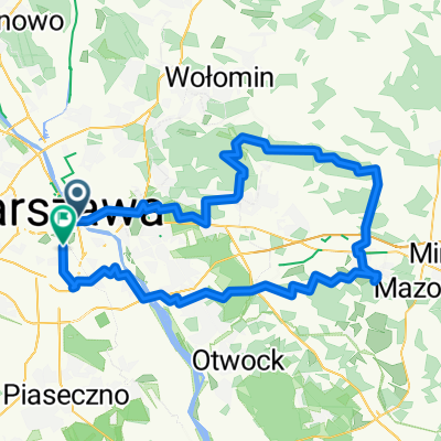
Katowicka do Walecznych
- 56.9 km
- 292 m
- 335 m
- Śródmieście, Masovian Voivodeship, Poland
A cycling route starting in Śródmieście, Masovian Voivodeship, Poland.
Overview
Pl. Zbawiciela - Marszalkowska - GREEN - Al. Armii Ludowej - Pl. Na Rozdrozu - VISTULA - Agrykola - Hoene-Wronskiego - Rozbrat - Smiglego-Rydza Park - Wioslarska - Kosciuszkowskie Embankment - Gdanskie Embankment - Gdynskie Embankment - Kepa Potocka Park - Gwiazdzista - VISTULA - Bielanski Forest - Dewajtis - Bielanski Forest - Northern Bridge Route - Marymoncka - Pulkowa - Heroldow - Encyclopedic - Michaliny - Anny Jagielonki - Dankowicka - Mlocinski Forest - Dabrowa Lesna - Kampinoska - Luze - Sierakowska - Dziekanow Lesny - Lutza - Kolejowa - Kampinoski National Park - Palmiry Cemetery / Museum - Zdrojowa Gora - Truskaw - YELLOW - Mariew - GREEN - Spacerowa - Borzecin - Royal Route - Zalesie - Klonowa - Koczargi Stare - Akacjowa - Lipkow - Kordeckiego - Izabelin B - YELLOW - Sienkiewicza - Izabelinska - Zielona - Pohulanka - Andersa - Losiowe Blota Reserve - Radiowa - Kutrzeby - Health Trail (forest pharmacy, singing tree, forest layers, forest safari) - Grotowska - Bemowo Airport - Kleberga - Dostepna - YELLOW - Radiowa - Andyjska - Sunset - Cursed Soldiers - Piastow Slaskich - Fort Bema - GREEN - Al. Prymasa Tysiaclecia - Lasek Na Kole - Dahlberga - Deotymy - Moczydlo Park - Gorczewska - Szymanski Park - Wolska - GREEN - Al. Prymasa Tysiaclecia - Battle of Warsaw 1920 - Banacha - Pole Mokotowskie - Rondo Jazdy Polskiej - Al. Armii Ludowej - Marszalkowska - Pl. Zbawiciela
created this 13 years ago
Continue with Bikemap
You would like to ride Plac Zbawiciela - Kampinoski Park Narodowy - Plac Zbawiciela or customize it for your own trip? Here is what you can do with this Bikemap route:
Free trial for 3 days, or one-time payment. More about Bikemap Premium.
Discover more Premium features.
Get Bikemap PremiumFrom our community
Open it in the app