

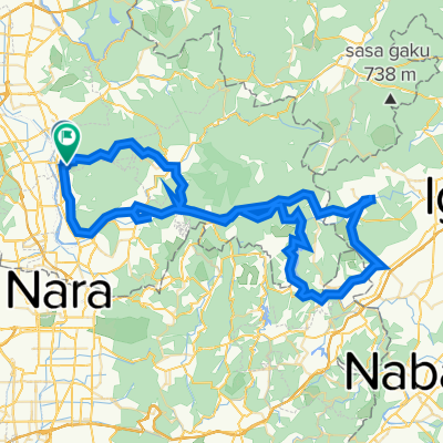
京都八幡木津自転車道線, 精華町へ兜台4丁目6-5, 木津川市
A cycling route starting in Tanabe, Kyoto, Japan.
Overview
About this route
- 1 h 1 min
- Duration
- 11 km
- Distance
- 142 m
- Ascent
- 73 m
- Descent
- 10.9 km/h
- Avg. speed
- 100 m
- Max. altitude

Route quality
Waytypes & surfaces along the route
Waytypes
Quiet road
5.7 km
(52 %)
Cycleway
2.8 km
(25 %)
Surfaces
Paved
0.3 km
(3 %)
Unpaved
0.9 km
(8 %)
Unpaved (undefined)
0.9 km
(8 %)
Paved (undefined)
0.3 km
(3 %)
Undefined
9.8 km
(89 %)
Continue with Bikemap
Use, edit, or download this cycling route
You would like to ride 京都八幡木津自転車道線, 精華町へ兜台4丁目6-5, 木津川市 or customize it for your own trip? Here is what you can do with this Bikemap route:
Free features
- Save this route as favorite or in collections
- Copy & plan your own version of this route
- Sync your route with Garmin or Wahoo
Premium features
Free trial for 3 days, or one-time payment. More about Bikemap Premium.
- Navigate this route on iOS & Android
- Export a GPX / KML file of this route
- Create your custom printout (try it for free)
- Download this route for offline navigation
Discover more Premium features.
Get Bikemap PremiumFrom our community
Other popular routes starting in Tanabe
 中出口42-1, 城陽市へ兜台4丁目18-17, 木津川市
- Distance
- 20.3 km
- Ascent
- 342 m
- Descent
- 269 m
- Location
- Tanabe, Kyoto, Japan
 京都八幡木津自転車道線, 精華町へ兜台4丁目6-5, 木津川市
- Distance
- 11 km
- Ascent
- 142 m
- Descent
- 73 m
- Location
- Tanabe, Kyoto, Japan
 京都八幡木津自転車道線, 京田辺市 to 春日野町, 奈良市
- Distance
- 24.9 km
- Ascent
- 197 m
- Descent
- 100 m
- Location
- Tanabe, Kyoto, Japan
 Long ride from Kyotanabe to Iga
- Distance
- 53.9 km
- Ascent
- 594 m
- Descent
- 474 m
- Location
- Tanabe, Kyoto, Japan
 Sato, Ide to Nishimaeda, Ide
- Distance
- 92.7 km
- Ascent
- 3,131 m
- Descent
- 3,125 m
- Location
- Tanabe, Kyoto, Japan
 山城グラベル
- Distance
- 13.1 km
- Ascent
- 506 m
- Descent
- 504 m
- Location
- Tanabe, Kyoto, Japan
 Kyotanabe - Osaka
- Distance
- 50 km
- Ascent
- 266 m
- Descent
- 314 m
- Location
- Tanabe, Kyoto, Japan
 【京都府】ルートラボで見る2018ツアー・オブ・ジャパン 第2ステージコースと沿線の街々を紹介
- Distance
- 99.1 km
- Ascent
- 2,601 m
- Descent
- 2,562 m
- Location
- Tanabe, Kyoto, Japan
Open it in the app