![[Inline]FFM-Sindlingen -> FFM Flughafen (Startbahn West)](/_next/static/media/contour-lines-light-small.cafd5e5d.avif)
![[Inline]FFM-Sindlingen -> FFM Flughafen (Startbahn West)](https://media.bikemap.net/routes/1627517/staticmaps/in_9b48bbfa-9c02-4ef3-b04e-e63981fe6a21_694x400_bikemap-2021-3D-static.png)
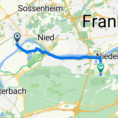
[Inline]FFM-Sindlingen -> FFM Flughafen (Startbahn West)
A cycling route starting in Kelsterbach, Hesse, Germany.
Overview
About this route
A nice little 'after-work route' from Frankfurt-Sindlingen to the viewing platform at the airport's west runway. The route is fully paved. Only the last 100 meters from the parking lot to the platform are gravel/sand. However, it is still easily manageable.
- -:--
- Duration
- 9.9 km
- Distance
- 31 m
- Ascent
- 30 m
- Descent
- ---
- Avg. speed
- ---
- Max. altitude
Route quality
Waytypes & surfaces along the route
Waytypes
Road
2.7 km
(27 %)
Path
2.7 km
(27 %)
Surfaces
Paved
9.5 km
(96 %)
Unpaved
0.2 km
(2 %)
Asphalt
9.5 km
(96 %)
Gravel
0.2 km
(2 %)
Undefined
0.2 km
(2 %)
Continue with Bikemap
Use, edit, or download this cycling route
You would like to ride [Inline]FFM-Sindlingen -> FFM Flughafen (Startbahn West) or customize it for your own trip? Here is what you can do with this Bikemap route:
Free features
- Save this route as favorite or in collections
- Copy & plan your own version of this route
- Sync your route with Garmin or Wahoo
Premium features
Free trial for 3 days, or one-time payment. More about Bikemap Premium.
- Navigate this route on iOS & Android
- Export a GPX / KML file of this route
- Create your custom printout (try it for free)
- Download this route for offline navigation
Discover more Premium features.
Get Bikemap PremiumFrom our community
Other popular routes starting in Kelsterbach
 Rund um den Flugplatz
- Distance
- 33.8 km
- Ascent
- 103 m
- Descent
- 103 m
- Location
- Kelsterbach, Hesse, Germany
 Lücki RR ins Ried 104km/286HM
- Distance
- 110.7 km
- Ascent
- 247 m
- Descent
- 248 m
- Location
- Kelsterbach, Hesse, Germany
 Brüningstraße, Frankfurt am Main nach Lyoner Straße, Frankfurt am Main
- Distance
- 8.9 km
- Ascent
- 381 m
- Descent
- 367 m
- Location
- Kelsterbach, Hesse, Germany
 Lavendelweg 13C, Kelsterbach nach Lavendelweg 13C, Kelsterbach
- Distance
- 62.8 km
- Ascent
- 457 m
- Descent
- 457 m
- Location
- Kelsterbach, Hesse, Germany
 Leunabrücke Höchst nach Mainz
- Distance
- 28.3 km
- Ascent
- 31 m
- Descent
- 38 m
- Location
- Kelsterbach, Hesse, Germany
 Rüsselsheimer Str, Kelsterbach nach Frankfurter Straße 31, Offenbach am Main
- Distance
- 27.2 km
- Ascent
- 10 m
- Descent
- 14 m
- Location
- Kelsterbach, Hesse, Germany
 Kelsterbach - Offenbach (19 Km)
- Distance
- 19 km
- Ascent
- 76 m
- Descent
- 61 m
- Location
- Kelsterbach, Hesse, Germany
 schwanheim lauf
- Distance
- 9.5 km
- Ascent
- 39 m
- Descent
- 39 m
- Location
- Kelsterbach, Hesse, Germany
Open it in the app