
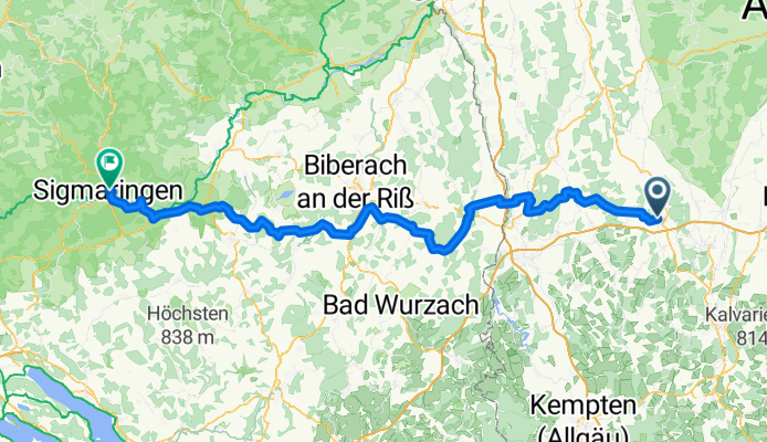
Overview
About this route
- 8 h 20 min
- Duration
- 134.8 km
- Distance
- 1,265 m
- Ascent
- 1,297 m
- Descent
- 16.2 km/h
- Avg. speed
- 708 m
- Max. altitude
Part of
Neckar 2025
4 stages
Route quality
Waytypes & surfaces along the route
Waytypes
Quiet road
67.4 km
(50 %)
Road
21.6 km
(16 %)
Surfaces
Paved
90.3 km
(67 %)
Unpaved
2.7 km
(2 %)
Asphalt
87.6 km
(65 %)
Paved (undefined)
2.7 km
(2 %)
Continue with Bikemap
Use, edit, or download this cycling route
You would like to ride MN Sigmaringen or customize it for your own trip? Here is what you can do with this Bikemap route:
Free features
- Save this route as favorite or in collections
- Copy & plan your own version of this route
- Split it into stages to create a multi-day tour
- Sync your route with Garmin or Wahoo
Premium features
Free trial for 3 days, or one-time payment. More about Bikemap Premium.
- Navigate this route on iOS & Android
- Export a GPX / KML file of this route
- Create your custom printout (try it for free)
- Download this route for offline navigation
Discover more Premium features.
Get Bikemap PremiumFrom our community
Other popular routes starting in Mindelheim
 Elbsee (Alternativbier)
- Distance
- 78.3 km
- Ascent
- 742 m
- Descent
- 687 m
- Location
- Mindelheim, Bavaria, Germany
 Allgäu - Aktivpark Kneippbad
- Distance
- 80.5 km
- Ascent
- 570 m
- Descent
- 569 m
- Location
- Mindelheim, Bavaria, Germany
 Hügelige Runde
- Distance
- 49.4 km
- Ascent
- 409 m
- Descent
- 409 m
- Location
- Mindelheim, Bavaria, Germany
 Allgäu - Unterallg Gartentour-MN-MM-var4
- Distance
- 38.8 km
- Ascent
- 372 m
- Descent
- 381 m
- Location
- Mindelheim, Bavaria, Germany
 Mindelheim - Kronburg
- Distance
- 76.7 km
- Ascent
- 555 m
- Descent
- 539 m
- Location
- Mindelheim, Bavaria, Germany
 17-Wörishofen-Katzbrui
- Distance
- 47.4 km
- Ascent
- 390 m
- Descent
- 391 m
- Location
- Mindelheim, Bavaria, Germany
 Mindelheim - Ammersee
- Distance
- 123.3 km
- Ascent
- 901 m
- Descent
- 897 m
- Location
- Mindelheim, Bavaria, Germany
 Mindelheim-Lindau
- Distance
- 97.1 km
- Ascent
- 311 m
- Descent
- 519 m
- Location
- Mindelheim, Bavaria, Germany
Open it in the app