
Neckar 2025
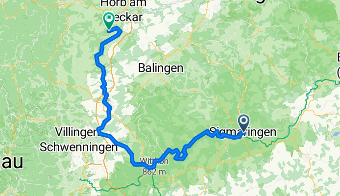
Sigmaringen Glatt am Neckar
A cycling route starting in Sigmaringen, Baden-Wurttemberg, Germany.
Overview
About this route
- 9 h 6 min
- Duration
- 135.7 km
- Distance
- 2,389 m
- Ascent
- 2,548 m
- Descent
- 14.9 km/h
- Avg. speed
- 764 m
- Max. altitude
Part of
Neckar 2025
4 stages
Route quality
Waytypes & surfaces along the route
Waytypes
Track
55.6 km
(41 %)
Quiet road
28.5 km
(21 %)
Surfaces
Paved
104.5 km
(77 %)
Unpaved
23.1 km
(17 %)
Asphalt
84.1 km
(62 %)
Paved (undefined)
19 km
(14 %)
Continue with Bikemap
Use, edit, or download this cycling route
You would like to ride Sigmaringen Glatt am Neckar or customize it for your own trip? Here is what you can do with this Bikemap route:
Free features
- Save this route as favorite or in collections
- Copy & plan your own version of this route
- Split it into stages to create a multi-day tour
- Sync your route with Garmin or Wahoo
Premium features
Free trial for 3 days, or one-time payment. More about Bikemap Premium.
- Navigate this route on iOS & Android
- Export a GPX / KML file of this route
- Create your custom printout (try it for free)
- Download this route for offline navigation
Discover more Premium features.
Get Bikemap PremiumFrom our community
Other popular routes starting in Sigmaringen
 Sigmaringen, Donauradweg bis Mengen, Zielfinger Seen, über Wildpark Josefslust zurück nach Sigmaringen.
- Distance
- 31.9 km
- Ascent
- 1,498 m
- Descent
- 1,494 m
- Location
- Sigmaringen, Baden-Wurttemberg, Germany
 19. Sigmaringen-Riedsee/Donaueschingen (izvor Dunava)
- Distance
- 86.6 km
- Ascent
- 1,358 m
- Descent
- 1,256 m
- Location
- Sigmaringen, Baden-Wurttemberg, Germany
 Tag 2 Sigmaringen nach Riedheim
- Distance
- 138 km
- Ascent
- 1,026 m
- Descent
- 1,150 m
- Location
- Sigmaringen, Baden-Wurttemberg, Germany
 Donauradweg Siegmaringen - Riedlingen
- Distance
- 35.3 km
- Ascent
- 148 m
- Descent
- 203 m
- Location
- Sigmaringen, Baden-Wurttemberg, Germany
 Sigmaringen Radfahren
- Distance
- 30.8 km
- Ascent
- 178 m
- Descent
- 178 m
- Location
- Sigmaringen, Baden-Wurttemberg, Germany
 Tour 1 - Schmeiental-Tour
- Distance
- 21.6 km
- Ascent
- 375 m
- Descent
- 375 m
- Location
- Sigmaringen, Baden-Wurttemberg, Germany
 Sigmaringen
- Distance
- 114.2 km
- Ascent
- 747 m
- Descent
- 757 m
- Location
- Sigmaringen, Baden-Wurttemberg, Germany
 Winterlingen bis fast Bitz - Laucherttal zurück
- Distance
- 49.2 km
- Ascent
- 515 m
- Descent
- 514 m
- Location
- Sigmaringen, Baden-Wurttemberg, Germany
Open it in the app