
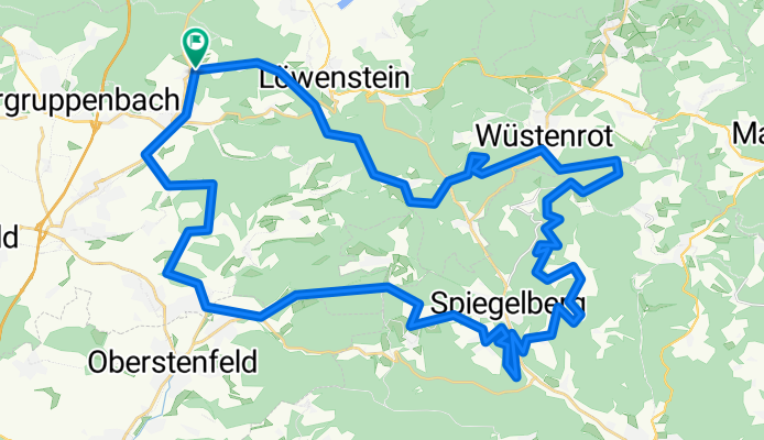
Stocksberg, Juxkopf Weicheitour
A cycling route starting in Lehrensteinsfeld, Baden-Wurttemberg, Germany.
Overview
About this route
Stocksberg, Juxkopf
- -:--
- Duration
- 59.7 km
- Distance
- 1,064 m
- Ascent
- 1,064 m
- Descent
- ---
- Avg. speed
- ---
- Max. altitude

Route quality
Waytypes & surfaces along the route
Waytypes
Track
44.2 km
(74 %)
Quiet road
5.4 km
(9 %)
Surfaces
Paved
20.3 km
(34 %)
Unpaved
37.6 km
(63 %)
Gravel
26.9 km
(45 %)
Asphalt
17.3 km
(29 %)
Continue with Bikemap
Use, edit, or download this cycling route
You would like to ride Stocksberg, Juxkopf Weicheitour or customize it for your own trip? Here is what you can do with this Bikemap route:
Free features
- Save this route as favorite or in collections
- Copy & plan your own version of this route
- Sync your route with Garmin or Wahoo
Premium features
Free trial for 3 days, or one-time payment. More about Bikemap Premium.
- Navigate this route on iOS & Android
- Export a GPX / KML file of this route
- Create your custom printout (try it for free)
- Download this route for offline navigation
Discover more Premium features.
Get Bikemap PremiumFrom our community
Other popular routes starting in Lehrensteinsfeld
 Lehrensteinsfeld - Wüstenrot
- Distance
- 51.5 km
- Ascent
- 1,042 m
- Descent
- 1,083 m
- Location
- Lehrensteinsfeld, Baden-Wurttemberg, Germany
 Obersulm - Neippberg - Heilbronn - Obersulm
- Distance
- 69.3 km
- Ascent
- 708 m
- Descent
- 708 m
- Location
- Lehrensteinsfeld, Baden-Wurttemberg, Germany
 Stocksberg, Juxkopf Weicheitour
- Distance
- 59.7 km
- Ascent
- 1,064 m
- Descent
- 1,064 m
- Location
- Lehrensteinsfeld, Baden-Wurttemberg, Germany
 Lehrensteinsfeld - Löwenstein
- Distance
- 25.4 km
- Ascent
- 434 m
- Descent
- 431 m
- Location
- Lehrensteinsfeld, Baden-Wurttemberg, Germany
 Nordwestl. Schwäbischer Wald
- Distance
- 100.2 km
- Ascent
- 1,572 m
- Descent
- 1,418 m
- Location
- Lehrensteinsfeld, Baden-Wurttemberg, Germany
 Affaltrach Lauffen a.N.
- Distance
- 25.4 km
- Ascent
- 292 m
- Descent
- 316 m
- Location
- Lehrensteinsfeld, Baden-Wurttemberg, Germany
 Runde durch Naturpark Fränkisch-Schwäbischer Wald
- Distance
- 91.5 km
- Ascent
- 963 m
- Descent
- 963 m
- Location
- Lehrensteinsfeld, Baden-Wurttemberg, Germany
 Rund um Obersulm
- Distance
- 31.2 km
- Ascent
- 541 m
- Descent
- 541 m
- Location
- Lehrensteinsfeld, Baden-Wurttemberg, Germany
Open it in the app