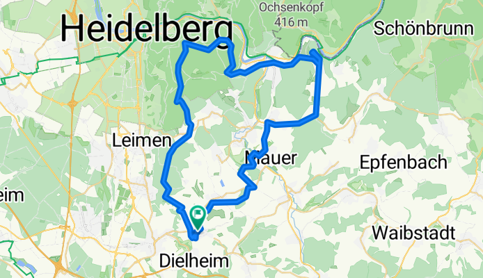
Zwei-Berge-Tour Teil 1 (nach GPS Log)
A cycling route starting in Dielheim, Baden-Württemberg, Germany.
Overview
About this route
Wiesloch-Baiertal, Königstuhl, Dilsberg
(GPS-Log)
- -:--
- Duration
- 49.1 km
- Distance
- 758 m
- Ascent
- 758 m
- Descent
- ---
- Avg. speed
- ---
- Max. altitude
Route quality
Waytypes & surfaces along the route
Waytypes
Track
22.7 km
(46 %)
Quiet road
6.8 km
(14 %)
Surfaces
Paved
19.6 km
(40 %)
Unpaved
20.5 km
(42 %)
Asphalt
19 km
(39 %)
Gravel
17.8 km
(36 %)
Continue with Bikemap
Use, edit, or download this cycling route
You would like to ride Zwei-Berge-Tour Teil 1 (nach GPS Log) or customize it for your own trip? Here is what you can do with this Bikemap route:
Free features
- Save this route as favorite or in collections
- Copy & plan your own version of this route
- Sync your route with Garmin or Wahoo
Premium features
Free trial for 3 days, or one-time payment. More about Bikemap Premium.
- Navigate this route on iOS & Android
- Export a GPX / KML file of this route
- Create your custom printout (try it for free)
- Download this route for offline navigation
Discover more Premium features.
Get Bikemap PremiumFrom our community
Other popular routes starting in Dielheim
- Dielheim - Tairnbach - Mühlhausen - Wiesloch
- Distance
- 23.1 km
- Ascent
- 193 m
- Descent
- 193 m
- Location
- Dielheim, Baden-Württemberg, Germany
- Kraichgau Ironman
- Distance
- 86.9 km
- Ascent
- 688 m
- Descent
- 688 m
- Location
- Dielheim, Baden-Württemberg, Germany
- Altern. Schulweg baiertal zum Schulzentrum
- Distance
- 4.2 km
- Ascent
- 26 m
- Descent
- 73 m
- Location
- Dielheim, Baden-Württemberg, Germany
- Schulweg von Baiertal zum Schulzentrum
- Distance
- 4.7 km
- Ascent
- 42 m
- Descent
- 70 m
- Location
- Dielheim, Baden-Württemberg, Germany
- Dielheim - Stuttgart
- Distance
- 96.4 km
- Ascent
- 728 m
- Descent
- 648 m
- Location
- Dielheim, Baden-Württemberg, Germany
- Dielheim zur SAP in Rot
- Distance
- 11.4 km
- Ascent
- 64 m
- Descent
- 99 m
- Location
- Dielheim, Baden-Württemberg, Germany
- Kurze Rundtour Baiertal-Unterhof-Schatthausen
- Distance
- 10.8 km
- Ascent
- 122 m
- Descent
- 140 m
- Location
- Dielheim, Baden-Württemberg, Germany
- Sensbachtal
- Distance
- 104.8 km
- Ascent
- 836 m
- Descent
- 836 m
- Location
- Dielheim, Baden-Württemberg, Germany
Open it in the app