
Mołdawia 2011
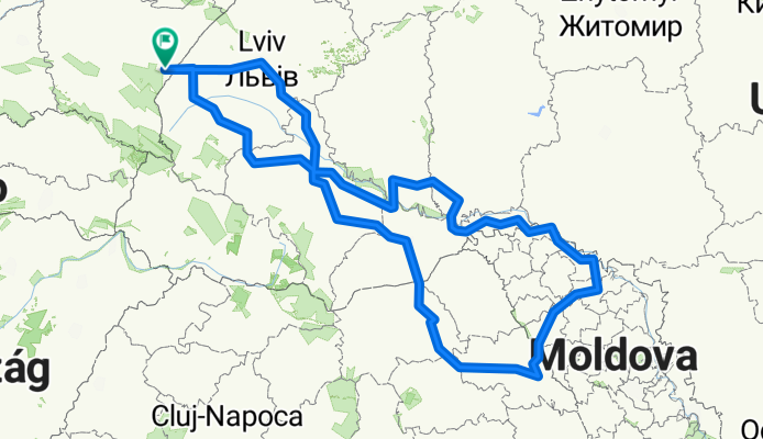
A cycling route starting in Przemyśl, Subcarpathian Voivodeship, Poland.
Overview
About this route
- -:--
- Duration
- 1,405.5 km
- Distance
- 1,442 m
- Ascent
- 1,441 m
- Descent
- ---
- Avg. speed
- ---
- Max. altitude
Continue with Bikemap
Use, edit, or download this cycling route
You would like to ride Mołdawia 2011 or customize it for your own trip? Here is what you can do with this Bikemap route:
Free features
- Save this route as favorite or in collections
- Copy & plan your own version of this route
- Split it into stages to create a multi-day tour
- Sync your route with Garmin or Wahoo
Premium features
Free trial for 3 days, or one-time payment. More about Bikemap Premium.
- Navigate this route on iOS & Android
- Export a GPX / KML file of this route
- Create your custom printout (try it for free)
- Download this route for offline navigation
Discover more Premium features.
Get Bikemap PremiumFrom our community
Other popular routes starting in Przemyśl
 Przemyśl-Prałkowce-Brylińce-Krasiczyn-Przemyśl
- Distance
- 41.2 km
- Ascent
- 487 m
- Descent
- 495 m
- Location
- Przemyśl, Subcarpathian Voivodeship, Poland
 Przemysl - wisan
- Distance
- 95.2 km
- Ascent
- 1,970 m
- Descent
- 1,692 m
- Location
- Przemyśl, Subcarpathian Voivodeship, Poland
 Przemyśl (Gmina) Bieg
- Distance
- 27.8 km
- Ascent
- 581 m
- Descent
- 582 m
- Location
- Przemyśl, Subcarpathian Voivodeship, Poland
 Przemyśl-Fredropol-Huwniki-Bircza-Przemyśl
- Distance
- 80.3 km
- Ascent
- 809 m
- Descent
- 796 m
- Location
- Przemyśl, Subcarpathian Voivodeship, Poland
 Cyklokarpaty 2013 - Twierdza Przemyśl - HOBBY
- Distance
- 11.6 km
- Ascent
- 322 m
- Descent
- 322 m
- Location
- Przemyśl, Subcarpathian Voivodeship, Poland
 Trasa rowerowa po fortach Twierdzy Przemyśl - cz. południowa
- Distance
- 51.7 km
- Ascent
- 545 m
- Descent
- 545 m
- Location
- Przemyśl, Subcarpathian Voivodeship, Poland
 Dookoła Polski 1dzień (Przemyśl-Nowa Wieś)
- Distance
- 32.4 km
- Ascent
- 465 m
- Descent
- 404 m
- Location
- Przemyśl, Subcarpathian Voivodeship, Poland
 Przemyśl-Lecka-Bachórz
- Distance
- 82.4 km
- Ascent
- 531 m
- Descent
- 563 m
- Location
- Przemyśl, Subcarpathian Voivodeship, Poland
Open it in the app