

Sweden and Norway 2023
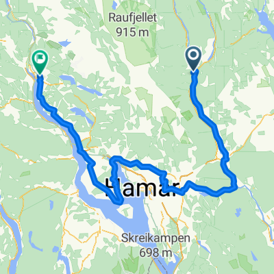
17.07.2023 - Bjornäsen-Nysatra-Oyungen-Ljosheimvegen-Birkebeinervegen-Sjusjo
A cycling route starting in Rena, Hedmark, Norway.
Overview
About this route
- -:--
- Duration
- 58.8 km
- Distance
- 588 m
- Ascent
- 1,077 m
- Descent
- ---
- Avg. speed
- 922 m
- Max. altitude

Part of
Sweden and Norway 2023
14 stages
Route photos

Route quality
Waytypes & surfaces along the route
Waytypes
Road
26.5 km
(45 %)
Quiet road
18.8 km
(32 %)
Surfaces
Paved
5.3 km
(9 %)
Unpaved
27.7 km
(47 %)
Gravel
23 km
(39 %)
Asphalt
5.3 km
(9 %)
Continue with Bikemap
Use, edit, or download this cycling route
You would like to ride 17.07.2023 - Bjornäsen-Nysatra-Oyungen-Ljosheimvegen-Birkebeinervegen-Sjusjo or customize it for your own trip? Here is what you can do with this Bikemap route:
Free features
- Save this route as favorite or in collections
- Copy & plan your own version of this route
- Sync your route with Garmin or Wahoo
Premium features
Free trial for 3 days, or one-time payment. More about Bikemap Premium.
- Navigate this route on iOS & Android
- Export a GPX / KML file of this route
- Create your custom printout (try it for free)
- Download this route for offline navigation
Discover more Premium features.
Get Bikemap PremiumFrom our community
Other popular routes starting in Rena
 Birkebeinerrittet 2022
- Distance
- 85.3 km
- Ascent
- 1,455 m
- Descent
- 1,410 m
- Location
- Rena, Hedmark, Norway
 Birkebeiner
- Distance
- 50.1 km
- Ascent
- 894 m
- Descent
- 711 m
- Location
- Rena, Hedmark, Norway
 Rena Cycling
- Distance
- 85.5 km
- Ascent
- 1,357 m
- Descent
- 1,304 m
- Location
- Rena, Hedmark, Norway
 06-rest
- Distance
- 769.3 km
- Ascent
- 7,108 m
- Descent
- 7,341 m
- Location
- Rena, Hedmark, Norway
 Rena-Kvarstadsetra-retur
- Distance
- 90.5 km
- Ascent
- 1,462 m
- Descent
- 1,465 m
- Location
- Rena, Hedmark, Norway
 Landeveisbirken CLONED FROM ROUTE 1034069
- Distance
- 172 km
- Ascent
- 943 m
- Descent
- 925 m
- Location
- Rena, Hedmark, Norway
 Birkebeienrrittet 2010
- Distance
- 91.1 km
- Ascent
- 1,190 m
- Descent
- 1,147 m
- Location
- Rena, Hedmark, Norway
 LV Birken CLONED FROM ROUTE 1029315
- Distance
- 168.6 km
- Ascent
- 1,094 m
- Descent
- 1,072 m
- Location
- Rena, Hedmark, Norway
Open it in the app