

Route de l'Aar
A cycling route starting in Koblenz, Canton of Aargau, Switzerland.
Overview
About this route
From Koblenz (AG) to Innertkirchen (BE) via the Aar cycle route (Switzerland by bike 8), except for the Burg-Golaten section (detour via Seeland).
Total effective distance: 340 km
Total positive elevation gain: 1700 m*
Duration: 3-4 days
- In the opposite direction (going downstream along the Aar): 1350 m
More information at www.europebybike.info
- -:--
- Duration
- 301.3 km
- Distance
- 585 m
- Ascent
- 280 m
- Descent
- ---
- Avg. speed
- ---
- Max. altitude

Route quality
Waytypes & surfaces along the route
Waytypes
Quiet road
120.5 km
(40 %)
Track
72.3 km
(24 %)
Surfaces
Paved
198.8 km
(66 %)
Unpaved
60.3 km
(20 %)
Asphalt
174.7 km
(58 %)
Gravel
39.2 km
(13 %)
Route highlights
Points of interest along the route
Point of interest after 1.5 km
Rhein Camping, Waldshut
Point of interest after 103.5 km
Camping Restaurant Muttenhof, Muttenstrasse, 4500 Solothurn, Tel. : 032 621 04 10
Point of interest after 235.1 km
Camping "Thunersee", Gwattstrasse 103a, 3645 Gwatt, Tél.: 033 336 40 67
Continue with Bikemap
Use, edit, or download this cycling route
You would like to ride Route de l'Aar or customize it for your own trip? Here is what you can do with this Bikemap route:
Free features
- Save this route as favorite or in collections
- Copy & plan your own version of this route
- Split it into stages to create a multi-day tour
- Sync your route with Garmin or Wahoo
Premium features
Free trial for 3 days, or one-time payment. More about Bikemap Premium.
- Navigate this route on iOS & Android
- Export a GPX / KML file of this route
- Create your custom printout (try it for free)
- Download this route for offline navigation
Discover more Premium features.
Get Bikemap PremiumFrom our community
Other popular routes starting in Koblenz
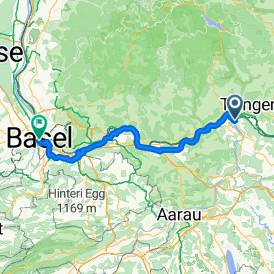 02 Koblenz - Basel
- Distance
- 70.9 km
- Ascent
- 437 m
- Descent
- 497 m
- Location
- Koblenz, Canton of Aargau, Switzerland
 02. Etappe: Koblenz-Titisee
- Distance
- 53.1 km
- Ascent
- 764 m
- Descent
- 241 m
- Location
- Koblenz, Canton of Aargau, Switzerland
 Waldshut - Lörrach
- Distance
- 68.4 km
- Ascent
- 194 m
- Descent
- 166 m
- Location
- Koblenz, Canton of Aargau, Switzerland
 Konstanz - Koblenz, neu
- Distance
- 121 km
- Ascent
- 316 m
- Descent
- 230 m
- Location
- Koblenz, Canton of Aargau, Switzerland
 Schaffhausen +
- Distance
- 101.1 km
- Ascent
- 858 m
- Descent
- 858 m
- Location
- Koblenz, Canton of Aargau, Switzerland
 Route de l'Aar
- Distance
- 301.3 km
- Ascent
- 585 m
- Descent
- 280 m
- Location
- Koblenz, Canton of Aargau, Switzerland
 Zwei Täler und Hallau
- Distance
- 88.6 km
- Ascent
- 1,247 m
- Descent
- 1,247 m
- Location
- Koblenz, Canton of Aargau, Switzerland
 4 dag waltshut Lörrach
- Distance
- 58.9 km
- Ascent
- 463 m
- Descent
- 483 m
- Location
- Koblenz, Canton of Aargau, Switzerland
Open it in the app