
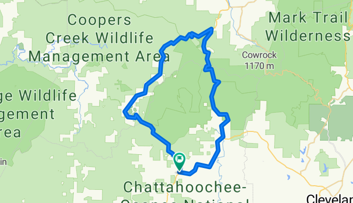
3 Gap counter clockwise
A cycling route starting in Dahlonega, Georgia, United States.
Overview
About this route
- -:--
- Duration
- 55.7 km
- Distance
- 1,033 m
- Ascent
- 1,033 m
- Descent
- ---
- Avg. speed
- ---
- Max. altitude
Route quality
Waytypes & surfaces along the route
Waytypes
Cycleway
24.5 km
(44 %)
Quiet road
3.3 km
(6 %)
Surfaces
Paved
47.9 km
(86 %)
Asphalt
47.9 km
(86 %)
Undefined
7.8 km
(14 %)
Continue with Bikemap
Use, edit, or download this cycling route
You would like to ride 3 Gap counter clockwise or customize it for your own trip? Here is what you can do with this Bikemap route:
Free features
- Save this route as favorite or in collections
- Copy & plan your own version of this route
- Sync your route with Garmin or Wahoo
Premium features
Free trial for 3 days, or one-time payment. More about Bikemap Premium.
- Navigate this route on iOS & Android
- Export a GPX / KML file of this route
- Create your custom printout (try it for free)
- Download this route for offline navigation
Discover more Premium features.
Get Bikemap PremiumFrom our community
Other popular routes starting in Dahlonega
 Jake with Cameron
- Distance
- 25.5 km
- Ascent
- 380 m
- Descent
- 380 m
- Location
- Dahlonega, Georgia, United States
 Moderate route
- Distance
- 19 km
- Ascent
- 402 m
- Descent
- 408 m
- Location
- Dahlonega, Georgia, United States
 Fool's Gold 50 2013 Race Course
- Distance
- 81.8 km
- Ascent
- 1,292 m
- Descent
- 1,291 m
- Location
- Dahlonega, Georgia, United States
 5–65 Wolf Pen Gap Rd, Suches to 1847–1851 SR-60, Suches
- Distance
- 9.2 km
- Ascent
- 171 m
- Descent
- 173 m
- Location
- Dahlonega, Georgia, United States
 1852 SR-60, Suches to US-19 N, Dahlonega
- Distance
- 11.8 km
- Ascent
- 161 m
- Descent
- 426 m
- Location
- Dahlonega, Georgia, United States
 flatland to fish knob
- Distance
- 22 km
- Ascent
- 658 m
- Descent
- 603 m
- Location
- Dahlonega, Georgia, United States
 Six Gap Valley Route Dahlonega, GA
- Distance
- 58.7 km
- Ascent
- 646 m
- Descent
- 646 m
- Location
- Dahlonega, Georgia, United States
 3 Gap counter clockwise
- Distance
- 55.7 km
- Ascent
- 1,033 m
- Descent
- 1,033 m
- Location
- Dahlonega, Georgia, United States
Open it in the app