

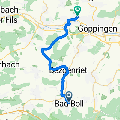
Bad Boll - Kreuzkapelle - Bosler - Bad Boll
A cycling route starting in Boll, Baden-Wurttemberg, Germany.
Overview
About this route
- -:--
- Duration
- 35.6 km
- Distance
- 704 m
- Ascent
- 705 m
- Descent
- ---
- Avg. speed
- ---
- Max. altitude

Route quality
Waytypes & surfaces along the route
Waytypes
Track
24.6 km
(69 %)
Quiet road
3.9 km
(11 %)
Surfaces
Paved
12.5 km
(35 %)
Unpaved
19.2 km
(54 %)
Gravel
12.1 km
(34 %)
Asphalt
9.6 km
(27 %)
Route highlights
Points of interest along the route

Point of interest after 1.7 km
Blick auf die 3 Königsberge

Point of interest after 15 km
Blick auf Albaufstieg der A8
Continue with Bikemap
Use, edit, or download this cycling route
You would like to ride Bad Boll - Kreuzkapelle - Bosler - Bad Boll or customize it for your own trip? Here is what you can do with this Bikemap route:
Free features
- Save this route as favorite or in collections
- Copy & plan your own version of this route
- Sync your route with Garmin or Wahoo
Premium features
Free trial for 3 days, or one-time payment. More about Bikemap Premium.
- Navigate this route on iOS & Android
- Export a GPX / KML file of this route
- Create your custom printout (try it for free)
- Download this route for offline navigation
Discover more Premium features.
Get Bikemap PremiumFrom our community
Other popular routes starting in Boll
 Bad Boll - Süßen über Auendorf
- Distance
- 28.2 km
- Ascent
- 539 m
- Descent
- 596 m
- Location
- Boll, Baden-Wurttemberg, Germany
 Bad Boll - Kreuzkapelle - Bosler - Bad Boll
- Distance
- 35.6 km
- Ascent
- 704 m
- Descent
- 705 m
- Location
- Boll, Baden-Wurttemberg, Germany
 Schön nach Kichheim unter Teck
- Distance
- 30.7 km
- Ascent
- 269 m
- Descent
- 269 m
- Location
- Boll, Baden-Wurttemberg, Germany
 Bad Boll - Kreuzkapelle - Bosler - Bad Boll
- Distance
- 35.6 km
- Ascent
- 751 m
- Descent
- 752 m
- Location
- Boll, Baden-Wurttemberg, Germany
 Filsursprung
- Distance
- 48.1 km
- Ascent
- 528 m
- Descent
- 530 m
- Location
- Boll, Baden-Wurttemberg, Germany
 Bad Boll - Süßen vs. Gruibingen, St. Gotthardt, Eislingen
- Distance
- 27.8 km
- Ascent
- 360 m
- Descent
- 426 m
- Location
- Boll, Baden-Wurttemberg, Germany
 Bad Boll - Plattfuß
- Distance
- 13.7 km
- Ascent
- 85 m
- Descent
- 183 m
- Location
- Boll, Baden-Wurttemberg, Germany
 Fuchseck
- Distance
- 27.4 km
- Ascent
- 444 m
- Descent
- 445 m
- Location
- Boll, Baden-Wurttemberg, Germany
Open it in the app