
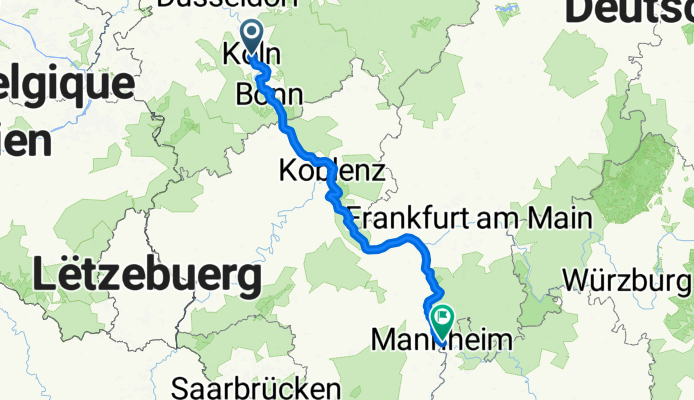
2 - Köln - Mannheim
A cycling route starting in Altstadt Nord, North Rhine-Westphalia, Germany.
Overview
About this route
Route: Erlebnisradweg Rheinschiene.
Rheinradweg
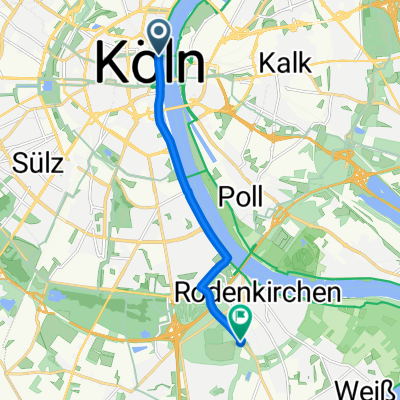
Heinrich- Böll- Platz
Hohenzollernbrücke
Köln- Deutz
Deutzer Hafen
Köln- Poll
Westhoven
Porz
Elsdorf
Wahn
Bur
Niederkassel
Rheidt
Siegquerung
Bonn- Castell
Gronau
Hochkreuz
Rüngsdorf
Mehlem
Rolandseck
Remagen
Sinzig
Bad Breisig
Andernach
Weissenthurm
Kaltengers
Sankt Sebastian
Wallersheim
Neuendorf
Moselquerung
Koblenz
Spay
Boppard
Bad- Salzig
St. Goar- Fellen
St. Goar
Oberwesel
Bacharach
Rheindiebach
Niederheinmach
Trechtingshausen
Bingen
Bingen- Kempten
Ingelheim- Nord
Budenheim
Mombach
Mainz
Weisenau
Nackenheim
Nierstein
Oppenheim
Hamm am Rhein
Ibersheim
Rheindürkheim
Worms
Petersau (Frankenthal/Pfalz)
BASF
Neckarstadt West
Neckarufer Kurpfalszbrücke (Mannheim)
- -:--
- Duration
- 278 km
- Distance
- 149 m
- Ascent
- 107 m
- Descent
- ---
- Avg. speed
- ---
- Max. altitude
Route quality
Waytypes & surfaces along the route
Waytypes
Path
118.4 km
(43 %)
Track
48.6 km
(17 %)
Surfaces
Paved
246 km
(88 %)
Unpaved
19.6 km
(7 %)
Asphalt
185.6 km
(67 %)
Paving stones
51.7 km
(19 %)
Continue with Bikemap
Use, edit, or download this cycling route
You would like to ride 2 - Köln - Mannheim or customize it for your own trip? Here is what you can do with this Bikemap route:
Free features
- Save this route as favorite or in collections
- Copy & plan your own version of this route
- Split it into stages to create a multi-day tour
- Sync your route with Garmin or Wahoo
Premium features
Free trial for 3 days, or one-time payment. More about Bikemap Premium.
- Navigate this route on iOS & Android
- Export a GPX / KML file of this route
- Create your custom printout (try it for free)
- Download this route for offline navigation
Discover more Premium features.
Get Bikemap PremiumFrom our community
Other popular routes starting in Altstadt Nord
 Köln . kleine Rheinrunde
- Distance
- 25.9 km
- Ascent
- 130 m
- Descent
- 130 m
- Location
- Altstadt Nord, North Rhine-Westphalia, Germany
 Köln - Koblenz
- Distance
- 95.1 km
- Ascent
- 123 m
- Descent
- 104 m
- Location
- Altstadt Nord, North Rhine-Westphalia, Germany
 Leichlingen Radtour
- Distance
- 62.3 km
- Ascent
- 172 m
- Descent
- 176 m
- Location
- Altstadt Nord, North Rhine-Westphalia, Germany
 Breite - A4 - Deutz - Zoobrücke - Hbf
- Distance
- 20.5 km
- Ascent
- 141 m
- Descent
- 145 m
- Location
- Altstadt Nord, North Rhine-Westphalia, Germany
 Im rechtsrheinischen Grüngürtel
- Distance
- 30.8 km
- Ascent
- 77 m
- Descent
- 67 m
- Location
- Altstadt Nord, North Rhine-Westphalia, Germany
 Forstbotanischer Garten, Köln
- Distance
- 7.5 km
- Ascent
- 41 m
- Descent
- 34 m
- Location
- Altstadt Nord, North Rhine-Westphalia, Germany
 Marienfeld / Papsthügel
- Distance
- 56.6 km
- Ascent
- 190 m
- Descent
- 185 m
- Location
- Altstadt Nord, North Rhine-Westphalia, Germany
 CYCLING THE RHINE: Route R11A
- Distance
- 59.2 km
- Ascent
- 97 m
- Descent
- 108 m
- Location
- Altstadt Nord, North Rhine-Westphalia, Germany
Open it in the app