
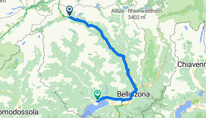
7. Tag Airolo-Locarno
A cycling route starting in Airolo, Canton Ticino, Switzerland.
Overview
About this route
- 5 h 26 min
- Duration
- 83.3 km
- Distance
- 881 m
- Ascent
- 1,845 m
- Descent
- 15.3 km/h
- Avg. speed
- 1,164 m
- Avg. speed
Route quality
Waytypes & surfaces along the route
Waytypes
Quiet road
26.1 km
(31 %)
Road
6.5 km
(8 %)
Surfaces
Paved
42.2 km
(51 %)
Unpaved
5.8 km
(7 %)
Asphalt
41.4 km
(50 %)
Unpaved (undefined)
2.2 km
(3 %)
Continue with Bikemap
Use, edit, or download this cycling route
You would like to ride 7. Tag Airolo-Locarno or customize it for your own trip? Here is what you can do with this Bikemap route:
Free features
- Save this route as favorite or in collections
- Copy & plan your own version of this route
- Split it into stages to create a multi-day tour
- Sync your route with Garmin or Wahoo
Premium features
Free trial for 3 days, or one-time payment. More about Bikemap Premium.
- Navigate this route on iOS & Android
- Export a GPX / KML file of this route
- Create your custom printout (try it for free)
- Download this route for offline navigation
Discover more Premium features.
Get Bikemap PremiumFrom our community
Other popular routes starting in Airolo
 Progetto N
- Distance
- 101.1 km
- Ascent
- 3,010 m
- Descent
- 3,010 m
- Location
- Airolo, Canton Ticino, Switzerland
 Upper Leventina
- Distance
- 49.8 km
- Ascent
- 746 m
- Descent
- 1,596 m
- Location
- Airolo, Canton Ticino, Switzerland
 TORTOUR 2012 TS08-TS09
- Distance
- 80.1 km
- Ascent
- 2,023 m
- Descent
- 2,659 m
- Location
- Airolo, Canton Ticino, Switzerland
 1_Airolo - Biasca
- Distance
- 116.2 km
- Ascent
- 3,060 m
- Descent
- 3,901 m
- Location
- Airolo, Canton Ticino, Switzerland
 Passo della Novena
- Distance
- 35.4 km
- Ascent
- 1,259 m
- Descent
- 1,262 m
- Location
- Airolo, Canton Ticino, Switzerland
 7. Tag Airolo-Locarno
- Distance
- 83.3 km
- Ascent
- 881 m
- Descent
- 1,845 m
- Location
- Airolo, Canton Ticino, Switzerland
 Nufenen, Gotthard, Furka
- Distance
- 96.1 km
- Ascent
- 2,984 m
- Descent
- 2,984 m
- Location
- Airolo, Canton Ticino, Switzerland
 airolo . tremola . san gottardo
- Distance
- 13.4 km
- Ascent
- 1,046 m
- Descent
- 100 m
- Location
- Airolo, Canton Ticino, Switzerland
Open it in the app