
Overview
About this route
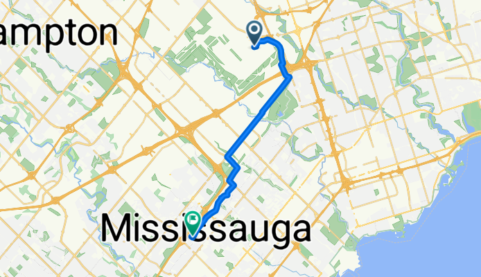
- 56 min
- Duration
- 15.4 km
- Distance
- 74 m
- Ascent
- 85 m
- Descent
- 16.5 km/h
- Avg. speed
- 171 m
- Avg. speed

Part of

Canada
17 stages
Route quality
Waytypes & surfaces along the route
Waytypes
Cycleway
7.2 km
(46 %)
Road
5.8 km
(38 %)
Surfaces
Paved
14.5 km
(94 %)
Asphalt
14.4 km
(94 %)
Concrete
0.1 km
(<1 %)
Continue with Bikemap
Use, edit, or download this cycling route
You would like to ride Day1_Airport Toronto to Mississauga or customize it for your own trip? Here is what you can do with this Bikemap route:
Free features
- Save this route as favorite or in collections
- Copy & plan your own version of this route
- Sync your route with Garmin or Wahoo
Premium features
Free trial for 3 days, or one-time payment. More about Bikemap Premium.
- Navigate this route on iOS & Android
- Export a GPX / KML file of this route
- Create your custom printout (try it for free)
- Download this route for offline navigation
Discover more Premium features.
Get Bikemap PremiumFrom our community
Other popular routes starting in Etobicoke
 Distilery
- Distance
- 24.9 km
- Ascent
- 84 m
- Descent
- 146 m
- Location
- Etobicoke, Ontario, Canada
 humber river trail
- Distance
- 33 km
- Ascent
- 585 m
- Descent
- 465 m
- Location
- Etobicoke, Ontario, Canada
 Humber - Eg - Royal York
- Distance
- 14.4 km
- Ascent
- 93 m
- Descent
- 93 m
- Location
- Etobicoke, Ontario, Canada
 Old Mill Return Via Humber River, Duck Pond, Centennial Park Conservatory, Etobicoke Creek, Lakeshore
- Distance
- 39.8 km
- Ascent
- 320 m
- Descent
- 303 m
- Location
- Etobicoke, Ontario, Canada
 Day1_Airport Toronto to Mississauga
- Distance
- 15.4 km
- Ascent
- 74 m
- Descent
- 85 m
- Location
- Etobicoke, Ontario, Canada
 Relaxed route in Toronto
- Distance
- 16.9 km
- Ascent
- 0 m
- Descent
- 0 m
- Location
- Etobicoke, Ontario, Canada
 OLD STREET ROUTE
- Distance
- 17.9 km
- Ascent
- 80 m
- Descent
- 81 m
- Location
- Etobicoke, Ontario, Canada
 Relaxed route in Toronto
- Distance
- 19.1 km
- Ascent
- 59 m
- Descent
- 60 m
- Location
- Etobicoke, Ontario, Canada
Open it in the app