

Cecis 2
A cycling route starting in Wetzelsdorf, Styria, Austria.
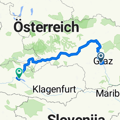
Overview
About this route
The Plabutsch loop par excellence! Alternatively, you can also take the Mantschawaldweg to the right towards the gasthaus Orthacker, then continue to the church of Johann and Paul (caution - gravel) and then proceed to the Fürstenstand. The descent to Göstingerstraße is quite challenging.
- -:--
- Duration
- 22.4 km
- Distance
- 598 m
- Ascent
- 591 m
- Descent
- ---
- Avg. speed
- 748 m
- Max. altitude

Route quality
Waytypes & surfaces along the route
Waytypes
Quiet road
13.9 km
(62 %)
Road
2.5 km
(11 %)
Surfaces
Paved
17.3 km
(77 %)
Unpaved
2.2 km
(10 %)
Asphalt
17.3 km
(77 %)
Gravel
1.6 km
(7 %)
Route highlights
Points of interest along the route
Point of interest after 2.8 km
Schloss St. Martin - toller Ausblick über Graz
Point of interest after 14.8 km
Gasthaus Fürstenstand - super Ausblick über Graz-Nord
Continue with Bikemap
Use, edit, or download this cycling route
You would like to ride Cecis 2 or customize it for your own trip? Here is what you can do with this Bikemap route:
Free features
- Save this route as favorite or in collections
- Copy & plan your own version of this route
- Sync your route with Garmin or Wahoo
Premium features
Free trial for 3 days, or one-time payment. More about Bikemap Premium.
- Navigate this route on iOS & Android
- Export a GPX / KML file of this route
- Create your custom printout (try it for free)
- Download this route for offline navigation
Discover more Premium features.
Get Bikemap PremiumFrom our community
Other popular routes starting in Wetzelsdorf
 JP+Fürstenstand
- Distance
- 28.1 km
- Ascent
- 596 m
- Descent
- 594 m
- Location
- Wetzelsdorf, Styria, Austria
 Graz Tobelbad Schwarzl Graz
- Distance
- 35.4 km
- Ascent
- 297 m
- Descent
- 297 m
- Location
- Wetzelsdorf, Styria, Austria
 Cecis 1
- Distance
- 15.6 km
- Ascent
- 355 m
- Descent
- 275 m
- Location
- Wetzelsdorf, Styria, Austria
 Cecis 2
- Distance
- 22.4 km
- Ascent
- 598 m
- Descent
- 591 m
- Location
- Wetzelsdorf, Styria, Austria
 Kreuzweg - Luderbauer - Orthacker - Aussichtswarte - Johann & Paul - Plabutsch - Gösting - Straßgang CLONED FROM ROUTE 1162102
- Distance
- 33 km
- Ascent
- 790 m
- Descent
- 790 m
- Location
- Wetzelsdorf, Styria, Austria
 Ride with Bernhard
- Distance
- 45.8 km
- Ascent
- 196 m
- Descent
- 197 m
- Location
- Wetzelsdorf, Styria, Austria
 Ekkehard-Hauer-Straße nach Burgplatz
- Distance
- 288.4 km
- Ascent
- 5,485 m
- Descent
- 5,279 m
- Location
- Wetzelsdorf, Styria, Austria
 Armin Laßnitzhöhe 80er
- Distance
- 79.6 km
- Ascent
- 679 m
- Descent
- 679 m
- Location
- Wetzelsdorf, Styria, Austria
Open it in the app