

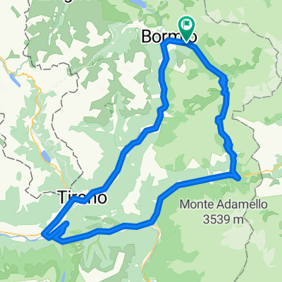
Bormio-Passo Stelvio (Cima)-Passo Umbrail-Sta Maria Val Müstair-Prato allo Stelvio-Trafoi-Passo Stelvio-Bormio
A cycling route starting in San Nicolò, Lombardy, Italy.
Overview
About this route
<span style="font-size: 7.5pt; font-family: Verdana, sans-serif;">Dolomitas 2.012</span> <span style="font-size: 7.5pt; line-height: 115%; font-family: Verdana, sans-serif;">Etapa nº 6 día 14 de julio, sabado</span>
- -:--
- Duration
- 109.8 km
- Distance
- 3,418 m
- Ascent
- 3,373 m
- Descent
- ---
- Avg. speed
- ---
- Max. altitude

Continue with Bikemap
Use, edit, or download this cycling route
You would like to ride Bormio-Passo Stelvio (Cima)-Passo Umbrail-Sta Maria Val Müstair-Prato allo Stelvio-Trafoi-Passo Stelvio-Bormio or customize it for your own trip? Here is what you can do with this Bikemap route:
Free features
- Save this route as favorite or in collections
- Copy & plan your own version of this route
- Split it into stages to create a multi-day tour
- Sync your route with Garmin or Wahoo
Premium features
Free trial for 3 days, or one-time payment. More about Bikemap Premium.
- Navigate this route on iOS & Android
- Export a GPX / KML file of this route
- Create your custom printout (try it for free)
- Download this route for offline navigation
Discover more Premium features.
Get Bikemap PremiumFrom our community
Other popular routes starting in San Nicolò
 Gavia-Mortirollo
- Distance
- 103.1 km
- Ascent
- 3,310 m
- Descent
- 3,332 m
- Location
- San Nicolò, Lombardy, Italy
 Bormio -Stelvio
- Distance
- 25.7 km
- Ascent
- 1,403 m
- Descent
- 618 m
- Location
- San Nicolò, Lombardy, Italy
 Valfurva - Gavia - Ponte di Legno - Monno - Edolo - Aprica - Tirano - Grosio - Bormio - Valfurva
- Distance
- 143.5 km
- Ascent
- 3,439 m
- Descent
- 3,439 m
- Location
- San Nicolò, Lombardy, Italy
 Umbrailtrail
- Distance
- 9.1 km
- Ascent
- 14 m
- Descent
- 1,106 m
- Location
- San Nicolò, Lombardy, Italy
 Valfurva - Gavia - Ponte di Legno - Monno - Mortirolo - Grosio - Valfurva
- Distance
- 109.2 km
- Ascent
- 3,673 m
- Descent
- 3,673 m
- Location
- San Nicolò, Lombardy, Italy
 9 sierpnia 2017
- Distance
- 128.5 km
- Ascent
- 2,077 m
- Descent
- 2,478 m
- Location
- San Nicolò, Lombardy, Italy
 Park Nazionale-Umbrail Pass-Sta.Maria-Prato-Stelvio-Passo Stelvio-Park Nazionale
- Distance
- 87 km
- Ascent
- 2,260 m
- Descent
- 3,109 m
- Location
- San Nicolò, Lombardy, Italy
 Bormio-Passo Stelvio (Cima)-Passo Umbrail-Sta Maria Val Müstair-Prato allo Stelvio-Trafoi-Passo Stelvio-Bormio
- Distance
- 109.8 km
- Ascent
- 3,418 m
- Descent
- 3,373 m
- Location
- San Nicolò, Lombardy, Italy
Open it in the app