
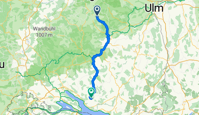
Hohenstein nach Salem
A cycling route starting in Gomadingen, Baden-Wurttemberg, Germany.
Overview
About this route
- 5 h 35 min
- Duration
- 94.9 km
- Distance
- 873 m
- Ascent
- 1,187 m
- Descent
- 17 km/h
- Avg. speed
- 767 m
- Max. altitude

Route quality
Waytypes & surfaces along the route
Waytypes
Quiet road
45.5 km
(48 %)
Track
30.4 km
(32 %)
Surfaces
Paved
84.5 km
(89 %)
Unpaved
4.7 km
(5 %)
Asphalt
81.6 km
(86 %)
Loose gravel
3.8 km
(4 %)
Continue with Bikemap
Use, edit, or download this cycling route
You would like to ride Hohenstein nach Salem or customize it for your own trip? Here is what you can do with this Bikemap route:
Free features
- Save this route as favorite or in collections
- Copy & plan your own version of this route
- Split it into stages to create a multi-day tour
- Sync your route with Garmin or Wahoo
Premium features
Free trial for 3 days, or one-time payment. More about Bikemap Premium.
- Navigate this route on iOS & Android
- Export a GPX / KML file of this route
- Create your custom printout (try it for free)
- Download this route for offline navigation
Discover more Premium features.
Get Bikemap PremiumFrom our community
Other popular routes starting in Gomadingen
 Tour 3 – Käsegeschichten
- Distance
- 34.1 km
- Ascent
- 294 m
- Descent
- 297 m
- Location
- Gomadingen, Baden-Wurttemberg, Germany
 Burg Derneck (Museumstour)
- Distance
- 40.6 km
- Ascent
- 630 m
- Descent
- 628 m
- Location
- Gomadingen, Baden-Wurttemberg, Germany
 OCC Mössingen
- Distance
- 31.6 km
- Ascent
- 382 m
- Descent
- 610 m
- Location
- Gomadingen, Baden-Wurttemberg, Germany
 Rdstrk. Gächingen, Marbach, Wasserstetten
- Distance
- 45.6 km
- Ascent
- 381 m
- Descent
- 381 m
- Location
- Gomadingen, Baden-Wurttemberg, Germany
 Herbstrunde St. Johann mit Armin
- Distance
- 28.5 km
- Ascent
- 258 m
- Descent
- 260 m
- Location
- Gomadingen, Baden-Wurttemberg, Germany
 Lautertal
- Distance
- 60.9 km
- Ascent
- 1,557 m
- Descent
- 1,556 m
- Location
- Gomadingen, Baden-Wurttemberg, Germany
 Buchbare Tour 3 | 1. Tag
- Distance
- 10.9 km
- Ascent
- 180 m
- Descent
- 146 m
- Location
- Gomadingen, Baden-Wurttemberg, Germany
 Von Hohenstein bis Pfronstetten
- Distance
- 32.1 km
- Ascent
- 909 m
- Descent
- 1,094 m
- Location
- Gomadingen, Baden-Wurttemberg, Germany
Open it in the app