

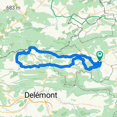
Laufen - Dittingen - Challhöchi - Röschenz - Laufen
A cycling route starting in Laufen, Basel-Landschaft, Switzerland.
Overview
About this route
Einfahren bis nach Dittingen. Dann Aufstieg mit teilweise sehr steilen Abschnitten auf die Challhöchi und danach mit rasanter Abfahrt nach Röschenz und Laufen via Fluh.
- -:--
- Duration
- 14.8 km
- Distance
- 462 m
- Ascent
- 462 m
- Descent
- ---
- Avg. speed
- ---
- Max. altitude
Route quality
Waytypes & surfaces along the route
Waytypes
Quiet road
6.7 km
(45 %)
Busy road
4.5 km
(30 %)
Surfaces
Paved
0.9 km
(6 %)
Unpaved
2.7 km
(18 %)
Gravel
1.5 km
(10 %)
Asphalt
0.9 km
(6 %)
Continue with Bikemap
Use, edit, or download this cycling route
You would like to ride Laufen - Dittingen - Challhöchi - Röschenz - Laufen or customize it for your own trip? Here is what you can do with this Bikemap route:
Free features
- Save this route as favorite or in collections
- Copy & plan your own version of this route
- Sync your route with Garmin or Wahoo
Premium features
Free trial for 3 days, or one-time payment. More about Bikemap Premium.
- Navigate this route on iOS & Android
- Export a GPX / KML file of this route
- Create your custom printout (try it for free)
- Download this route for offline navigation
Discover more Premium features.
Get Bikemap PremiumFrom our community
Other popular routes starting in Laufen
 Laufen–Oberbeinwil–Nunningen–Seewen–Laufen
- Distance
- 47.2 km
- Ascent
- 682 m
- Descent
- 682 m
- Location
- Laufen, Basel-Landschaft, Switzerland
 Laufen-Löwenburg
- Distance
- 42.1 km
- Ascent
- 641 m
- Descent
- 640 m
- Location
- Laufen, Basel-Landschaft, Switzerland
 19.01.2020 Huggerwald
- Distance
- 18.3 km
- Ascent
- 321 m
- Descent
- 320 m
- Location
- Laufen, Basel-Landschaft, Switzerland
 Laufen – Binningen
- Distance
- 25.8 km
- Ascent
- 528 m
- Descent
- 574 m
- Location
- Laufen, Basel-Landschaft, Switzerland
 31.08.2020 Bergmattenhof via Chall
- Distance
- 16.8 km
- Ascent
- 441 m
- Descent
- 441 m
- Location
- Laufen, Basel-Landschaft, Switzerland
 Breitenbach-Biel-Oensingen-Langenbruck-Reigoldswil-Breitenbach
- Distance
- 163.6 km
- Ascent
- 2,304 m
- Descent
- 2,084 m
- Location
- Laufen, Basel-Landschaft, Switzerland
 Huggerwald
- Distance
- 18.6 km
- Ascent
- 489 m
- Descent
- 491 m
- Location
- Laufen, Basel-Landschaft, Switzerland
 Enge Gasse 9, Laufen to Mörsbergerstrasse 24–30, Basel
- Distance
- 27.1 km
- Ascent
- 381 m
- Descent
- 475 m
- Location
- Laufen, Basel-Landschaft, Switzerland
Open it in the app