
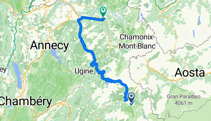
Cluses - Arc 2000
A cycling route starting in Séez, Auvergne-Rhône-Alpes, France.
Overview
About this route
- -:--
- Duration
- 160.9 km
- Distance
- 2,713 m
- Ascent
- 4,471 m
- Descent
- ---
- Avg. speed
- ---
- Max. altitude

Route quality
Waytypes & surfaces along the route
Waytypes
Road
24.1 km
(15 %)
Quiet road
4.8 km
(3 %)
Surfaces
Paved
115.9 km
(72 %)
Unpaved
1.6 km
(1 %)
Asphalt
115.9 km
(72 %)
Gravel
1.6 km
(1 %)
Undefined
43.5 km
(27 %)
Route highlights
Points of interest along the route
Point of interest after 1.6 km
Arc 2000
Point of interest after 46.8 km
Cormet de Roselend
Point of interest after 82.7 km
Col des Saisies
Point of interest after 91.6 km
Col de la Forclaz
Point of interest after 111.8 km
Col des Aravis
Continue with Bikemap
Use, edit, or download this cycling route
You would like to ride Cluses - Arc 2000 or customize it for your own trip? Here is what you can do with this Bikemap route:
Free features
- Save this route as favorite or in collections
- Copy & plan your own version of this route
- Split it into stages to create a multi-day tour
- Sync your route with Garmin or Wahoo
Premium features
Free trial for 3 days, or one-time payment. More about Bikemap Premium.
- Navigate this route on iOS & Android
- Export a GPX / KML file of this route
- Create your custom printout (try it for free)
- Download this route for offline navigation
Discover more Premium features.
Get Bikemap PremiumFrom our community
Other popular routes starting in Séez
 GTA3 J3 Seez (Bourg-St-Maurice) - Aussois
- Distance
- 93.8 km
- Ascent
- 2,867 m
- Descent
- 2,277 m
- Location
- Séez, Auvergne-Rhône-Alpes, France
 La Trank's
- Distance
- 4.2 km
- Ascent
- 28 m
- Descent
- 382 m
- Location
- Séez, Auvergne-Rhône-Alpes, France
 45DN - Montgirod & back streets to La Monal bar
- Distance
- 51 km
- Ascent
- 833 m
- Descent
- 1,300 m
- Location
- Séez, Auvergne-Rhône-Alpes, France
 Briançon - Arc 2000
- Distance
- 203 km
- Ascent
- 3,914 m
- Descent
- 4,894 m
- Location
- Séez, Auvergne-Rhône-Alpes, France
 ALPOK EXPEDÍCIÓ (2015) 17. nap - Szerda
- Distance
- 193.2 km
- Ascent
- 831 m
- Descent
- 2,778 m
- Location
- Séez, Auvergne-Rhône-Alpes, France
 Col de l'Iseran
- Distance
- 76.5 km
- Ascent
- 1,977 m
- Descent
- 1,473 m
- Location
- Séez, Auvergne-Rhône-Alpes, France
 Iseran
- Distance
- 42.6 km
- Ascent
- 2,037 m
- Descent
- 136 m
- Location
- Séez, Auvergne-Rhône-Alpes, France
 Cluses - Arc 2000
- Distance
- 160.9 km
- Ascent
- 2,713 m
- Descent
- 4,471 m
- Location
- Séez, Auvergne-Rhône-Alpes, France
Open it in the app