

Reblausexpress Radweg gross
A cycling route starting in Langau, Lower Austria, Austria.
Overview
About this route
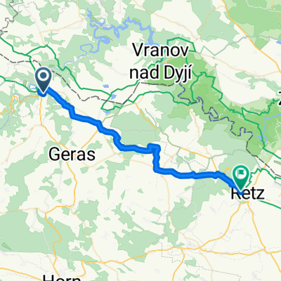
An idyllic bike tour along the tracks of the nostalgic Reblaus Express: through small villages, lush vineyards, and wide fields, the route leads to the wine town of Retz.
- -:--
- Duration
- 51.1 km
- Distance
- 455 m
- Ascent
- 631 m
- Descent
- ---
- Avg. speed
- 483 m
- Max. altitude

Route quality
Waytypes & surfaces along the route
Waytypes
Track
21 km
(41 %)
Road
17.4 km
(34 %)
Surfaces
Paved
21 km
(41 %)
Unpaved
8.2 km
(16 %)
Asphalt
19.4 km
(38 %)
Gravel
5.6 km
(11 %)
Continue with Bikemap
Use, edit, or download this cycling route
You would like to ride Reblausexpress Radweg gross or customize it for your own trip? Here is what you can do with this Bikemap route:
Free features
- Save this route as favorite or in collections
- Copy & plan your own version of this route
- Sync your route with Garmin or Wahoo
Premium features
Free trial for 3 days, or one-time payment. More about Bikemap Premium.
- Navigate this route on iOS & Android
- Export a GPX / KML file of this route
- Create your custom printout (try it for free)
- Download this route for offline navigation
Discover more Premium features.
Get Bikemap PremiumFrom our community
Other popular routes starting in Langau
 Drosendorf Altstadt nach Drosendorf Altstadt
- Distance
- 55.6 km
- Ascent
- 929 m
- Descent
- 945 m
- Location
- Langau, Lower Austria, Austria
 Reblaus Radweg
- Distance
- 34.6 km
- Ascent
- 315 m
- Descent
- 419 m
- Location
- Langau, Lower Austria, Austria
 Reblausexpress Radweg gross
- Distance
- 51.1 km
- Ascent
- 455 m
- Descent
- 631 m
- Location
- Langau, Lower Austria, Austria
 Reblaus-Radl-Weg_Drosendorf nach Retz
- Distance
- 34.4 km
- Ascent
- 377 m
- Descent
- 492 m
- Location
- Langau, Lower Austria, Austria
 Von Drosendorf nach Retz
- Distance
- 50 km
- Ascent
- 459 m
- Descent
- 630 m
- Location
- Langau, Lower Austria, Austria
 KTM3
KTM3- Distance
- 112.9 km
- Ascent
- 727 m
- Descent
- 841 m
- Location
- Langau, Lower Austria, Austria
 Reblausexpress Radweg
- Distance
- 51.1 km
- Ascent
- 455 m
- Descent
- 630 m
- Location
- Langau, Lower Austria, Austria
 Klimarundweg
- Distance
- 22.7 km
- Ascent
- 229 m
- Descent
- 231 m
- Location
- Langau, Lower Austria, Austria
Open it in the app