

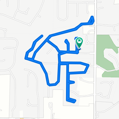
The Loop option 2
A cycling route starting in Wentzville, Missouri, United States.
Overview
About this route
- -:--
- Duration
- 58.1 km
- Distance
- 259 m
- Ascent
- 259 m
- Descent
- ---
- Avg. speed
- ---
- Max. altitude
Route quality
Waytypes & surfaces along the route
Waytypes
Quiet road
25.6 km
(44 %)
Road
13.4 km
(23 %)
Surfaces
Paved
16.3 km
(28 %)
Paved (undefined)
11 km
(19 %)
Asphalt
4.6 km
(8 %)
Continue with Bikemap
Use, edit, or download this cycling route
You would like to ride The Loop option 2 or customize it for your own trip? Here is what you can do with this Bikemap route:
Free features
- Save this route as favorite or in collections
- Copy & plan your own version of this route
- Sync your route with Garmin or Wahoo
Premium features
Free trial for 3 days, or one-time payment. More about Bikemap Premium.
- Navigate this route on iOS & Android
- Export a GPX / KML file of this route
- Create your custom printout (try it for free)
- Download this route for offline navigation
Discover more Premium features.
Get Bikemap PremiumFrom our community
Other popular routes starting in Wentzville
 The Loop option 2
- Distance
- 58.1 km
- Ascent
- 259 m
- Descent
- 259 m
- Location
- Wentzville, Missouri, United States
 Wentzville to New Melle
- Distance
- 45.7 km
- Ascent
- 463 m
- Descent
- 465 m
- Location
- Wentzville, Missouri, United States
 100 Bluestem Way, Wentzville to 100 Bluestem Way, Wentzville
- Distance
- 10.6 km
- Ascent
- 109 m
- Descent
- 108 m
- Location
- Wentzville, Missouri, United States
 The loop
- Distance
- 50.1 km
- Ascent
- 277 m
- Descent
- 277 m
- Location
- Wentzville, Missouri, United States
 Wentzville route
- Distance
- 14.6 km
- Ascent
- 125 m
- Descent
- 123 m
- Location
- Wentzville, Missouri, United States
 10 Bear Fountain Ct, Wentzville to 12 Bear Fountain Ct, Wentzville
- Distance
- 17.7 km
- Ascent
- 166 m
- Descent
- 166 m
- Location
- Wentzville, Missouri, United States
 10 Bear Fountain Ct, Wentzville to 12 Bear Fountain Ct, Wentzville
- Distance
- 6.9 km
- Ascent
- 81 m
- Descent
- 81 m
- Location
- Wentzville, Missouri, United States
 Long ride through St. Louis
- Distance
- 108.9 km
- Ascent
- 254 m
- Descent
- 290 m
- Location
- Wentzville, Missouri, United States
Open it in the app