
Geiseljoch - Zillertal - Runde
A cycling route starting in Mayrhofen, Tyrol, Austria.
Overview
About this route
vgl. mit Ziller-Special BIKE 2007 Tour 2
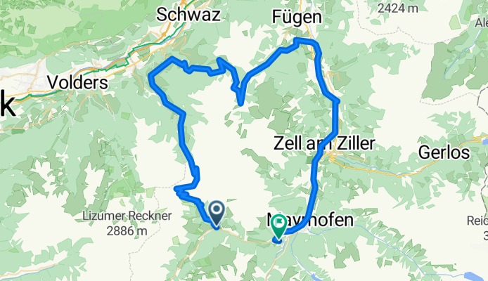
Start in Voderlanersbach, Parkplatz, über Geiseljoch, Innerst, Weerberg, Loassattel, Hochfügen, Uderns, Mayrhofen
Ende an der Unterkunft
- -:--
- Duration
- 80.3 km
- Distance
- 2,196 m
- Ascent
- 2,548 m
- Descent
- ---
- Avg. speed
- ---
- Avg. speed
Route quality
Waytypes & surfaces along the route
Waytypes
Track
47.6 km
(59 %)
Quiet road
14.9 km
(19 %)
Surfaces
Paved
26.6 km
(33 %)
Unpaved
38.5 km
(48 %)
Gravel
32.3 km
(40 %)
Asphalt
23.6 km
(29 %)
Continue with Bikemap
Use, edit, or download this cycling route
You would like to ride Geiseljoch - Zillertal - Runde or customize it for your own trip? Here is what you can do with this Bikemap route:
Free features
- Save this route as favorite or in collections
- Copy & plan your own version of this route
- Split it into stages to create a multi-day tour
- Sync your route with Garmin or Wahoo
Premium features
Free trial for 3 days, or one-time payment. More about Bikemap Premium.
- Navigate this route on iOS & Android
- Export a GPX / KML file of this route
- Create your custom printout (try it for free)
- Download this route for offline navigation
Discover more Premium features.
Get Bikemap PremiumFrom our community
Other popular routes starting in Mayrhofen
 Mayrh. Pfundsalm Fügen
- Distance
- 58.6 km
- Ascent
- 1,657 m
- Descent
- 1,657 m
- Location
- Mayrhofen, Tyrol, Austria
 Alpencross 2te
- Distance
- 117 km
- Ascent
- 3,629 m
- Descent
- 3,630 m
- Location
- Mayrhofen, Tyrol, Austria
 Stilluptal
- Distance
- 36 km
- Ascent
- 831 m
- Descent
- 829 m
- Location
- Mayrhofen, Tyrol, Austria
 Zillertaler Berg Klassiker
- Distance
- 120 km
- Ascent
- 2,140 m
- Descent
- 2,101 m
- Location
- Mayrhofen, Tyrol, Austria
 Tortour de Zillertal
- Distance
- 147.2 km
- Ascent
- 3,072 m
- Descent
- 3,072 m
- Location
- Mayrhofen, Tyrol, Austria
 MTB-Alpencross Tegernsee - Villanders bei Bozen - Etappe 3: Ginzling-Schabs
- Distance
- 71.3 km
- Ascent
- 1,311 m
- Descent
- 1,560 m
- Location
- Mayrhofen, Tyrol, Austria
 Zum Schlegeis Stausee
- Distance
- 45.7 km
- Ascent
- 1,157 m
- Descent
- 1,160 m
- Location
- Mayrhofen, Tyrol, Austria
 Route in Finkenberg
- Distance
- 74.2 km
- Ascent
- 1,961 m
- Descent
- 1,995 m
- Location
- Mayrhofen, Tyrol, Austria
Open it in the app