

6. etapa Coursavy - St Chely d Aubrac
A cycling route starting in Livinhac-le-Haut, Occitanie, France.
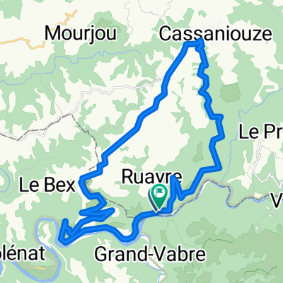
Overview
About this route
<p><strong><span style='font-size: 11pt; line-height: 115%; font-family: Calibri, sans-serif;'>Campsite in St Chély d'Aubrac</span></strong></p>
<p></p>
<p>Nice grassy campsite / hot water no problem / electrical power source in the washing area one socket with grounding pin (other sockets are at the washbasins) / internet not available / at the village entrance there are signs to the campsite / no mobile signal / on the night of the 7th to 8th a huge cloudburst (several times)</p>
<p></p>
<p><strong>Data from the bike computer:</strong><br />route 83.67 km / climbed 1521 meters / 4:50:43 hours</p>
<p></p>
Translated, show original (French)- -:--
- Duration
- 80.3 km
- Distance
- 1,318 m
- Ascent
- 712 m
- Descent
- ---
- Avg. speed
- ---
- Max. altitude

Route quality
Waytypes & surfaces along the route
Waytypes
Road
31.3 km
(39 %)
Quiet road
4 km
(5 %)
Surfaces
Paved
48.2 km
(60 %)
Unpaved
0.8 km
(1 %)
Asphalt
48.2 km
(60 %)
Ground
0.8 km
(1 %)
Undefined
31.3 km
(39 %)
Route highlights
Points of interest along the route
Point of interest after 8.7 km
CONQUES - nádherné historické městečko, kde se snad zastavil čas.
Point of interest after 32.1 km
Oběd
Point of interest after 46.4 km
Estaing
Point of interest after 57.5 km
Laciná benzínová pumpa
Continue with Bikemap
Use, edit, or download this cycling route
You would like to ride 6. etapa Coursavy - St Chely d Aubrac or customize it for your own trip? Here is what you can do with this Bikemap route:
Free features
- Save this route as favorite or in collections
- Copy & plan your own version of this route
- Split it into stages to create a multi-day tour
- Sync your route with Garmin or Wahoo
Premium features
Free trial for 3 days, or one-time payment. More about Bikemap Premium.
- Navigate this route on iOS & Android
- Export a GPX / KML file of this route
- Create your custom printout (try it for free)
- Download this route for offline navigation
Discover more Premium features.
Get Bikemap PremiumFrom our community
Other popular routes starting in Livinhac-le-Haut
 Dag 6 Saint Projet- Cahors Camping Riviere de Cabessut
- Distance
- 121 km
- Ascent
- 820 m
- Descent
- 928 m
- Location
- Livinhac-le-Haut, Occitanie, France
 Entraygues-Falcou
- Distance
- 174.3 km
- Ascent
- 1,026 m
- Descent
- 1,078 m
- Location
- Livinhac-le-Haut, Occitanie, France
 6. etapa Coursavy - St Chely d Aubrac
- Distance
- 80.3 km
- Ascent
- 1,318 m
- Descent
- 712 m
- Location
- Livinhac-le-Haut, Occitanie, France
 Deutschland - Portugal (Berlin - Faro) FR 24 Livinhac-le-Haut - Cajarc
- Distance
- 49.5 km
- Ascent
- 482 m
- Descent
- 529 m
- Location
- Livinhac-le-Haut, Occitanie, France
 Lot3
Lot3- Distance
- 25.1 km
- Ascent
- 646 m
- Descent
- 625 m
- Location
- Livinhac-le-Haut, Occitanie, France
 Pont de Coursavy - Aurillac (Nr. 133)
- Distance
- 45.6 km
- Ascent
- 858 m
- Descent
- 464 m
- Location
- Livinhac-le-Haut, Occitanie, France
 RNR CAMP #2 -a-
- Distance
- 228.1 km
- Ascent
- 2,469 m
- Descent
- 2,273 m
- Location
- Livinhac-le-Haut, Occitanie, France
 Pont de Coursavy - Corn (Nr. 102 + 99)
- Distance
- 59.2 km
- Ascent
- 896 m
- Descent
- 880 m
- Location
- Livinhac-le-Haut, Occitanie, France
Open it in the app