

Phase 3
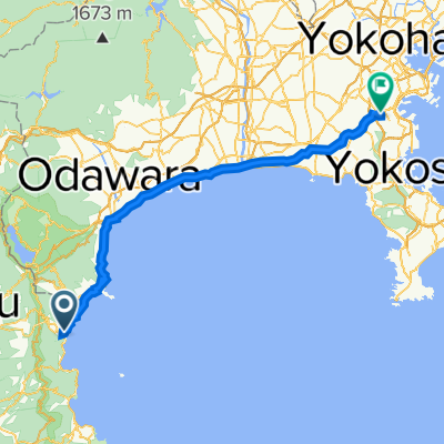
A cycling route starting in Atami, Shizuoka, Japan.
Overview
About this route
Converted from a KML file KML2GPX.COM - This is track no: 1
- 5 h 22 min
- Duration
- 83.5 km
- Distance
- 1,228 m
- Ascent
- 1,341 m
- Descent
- 15.6 km/h
- Avg. speed
- 501 m
- Max. altitude
Continue with Bikemap
Use, edit, or download this cycling route
You would like to ride Phase 3 or customize it for your own trip? Here is what you can do with this Bikemap route:
Free features
- Save this route as favorite or in collections
- Copy & plan your own version of this route
- Split it into stages to create a multi-day tour
- Sync your route with Garmin or Wahoo
Premium features
Free trial for 3 days, or one-time payment. More about Bikemap Premium.
- Navigate this route on iOS & Android
- Export a GPX / KML file of this route
- Create your custom printout (try it for free)
- Download this route for offline navigation
Discover more Premium features.
Get Bikemap PremiumFrom our community
Other popular routes starting in Atami
 11-1, Tawarahoncho, Atami-Shi to 1-1, Shiroyama 1-Chōme, Odawara-Shi
- Distance
- 27.2 km
- Ascent
- 977 m
- Descent
- 1,051 m
- Location
- Atami, Shizuoka, Japan
 tomorrow
- Distance
- 83 km
- Ascent
- 2,524 m
- Descent
- 2,597 m
- Location
- Atami, Shizuoka, Japan
 tokyo - kyoto part3
- Distance
- 166.4 km
- Ascent
- 811 m
- Descent
- 868 m
- Location
- Atami, Shizuoka, Japan
 9/24 Atami to Yokohama
- Distance
- 91.2 km
- Ascent
- 702 m
- Descent
- 764 m
- Location
- Atami, Shizuoka, Japan
 2, Atami to 6-chōme 20, Yokohama
- Distance
- 71.8 km
- Ascent
- 481 m
- Descent
- 429 m
- Location
- Atami, Shizuoka, Japan
 ToJ18 - Atami Circuit (Hilly)
- Distance
- 71.9 km
- Ascent
- 1,595 m
- Descent
- 1,573 m
- Location
- Atami, Shizuoka, Japan
 osaka from atami
- Distance
- 418.2 km
- Ascent
- 3,040 m
- Descent
- 3,114 m
- Location
- Atami, Shizuoka, Japan
 Restful route in Shimizu-Ku, Shizuoka-Shi
- Distance
- 61.2 km
- Ascent
- 1,138 m
- Descent
- 1,195 m
- Location
- Atami, Shizuoka, Japan
Open it in the app