

Phase 7
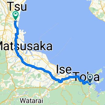
A cycling route starting in Toba, Mie, Japan.
Overview
About this route
None
- 4 h 36 min
- Duration
- 78.9 km
- Distance
- 410 m
- Ascent
- 362 m
- Descent
- 17.1 km/h
- Avg. speed
- 85 m
- Max. altitude
Route quality
Waytypes & surfaces along the route
Waytypes
Quiet road
63.9 km
(81 %)
Track
7.1 km
(9 %)
Surfaces
Paved
20.5 km
(26 %)
Paved (undefined)
19.7 km
(25 %)
Asphalt
0.8 km
(1 %)
Undefined
58.4 km
(74 %)
Continue with Bikemap
Use, edit, or download this cycling route
You would like to ride Phase 7 or customize it for your own trip? Here is what you can do with this Bikemap route:
Free features
- Save this route as favorite or in collections
- Copy & plan your own version of this route
- Sync your route with Garmin or Wahoo
Premium features
Free trial for 3 days, or one-time payment. More about Bikemap Premium.
- Navigate this route on iOS & Android
- Export a GPX / KML file of this route
- Create your custom printout (try it for free)
- Download this route for offline navigation
Discover more Premium features.
Get Bikemap PremiumFrom our community
Other popular routes starting in Toba
 Length of Japan Toba-Tsu
- Distance
- 57.8 km
- Ascent
- 79 m
- Descent
- 81 m
- Location
- Toba, Mie, Japan
 5: Toba to Kyoto
- Distance
- 151.7 km
- Ascent
- 465 m
- Descent
- 438 m
- Location
- Toba, Mie, Japan
 Cycling the Length of Japan: Kansai
- Distance
- 208.7 km
- Ascent
- 2,398 m
- Descent
- 2,398 m
- Location
- Toba, Mie, Japan
 Length of Japan Toba-Tsu
- Distance
- 57.7 km
- Ascent
- 243 m
- Descent
- 242 m
- Location
- Toba, Mie, Japan
 Ise-Farm
- Distance
- 92 km
- Ascent
- 761 m
- Descent
- 490 m
- Location
- Toba, Mie, Japan
 2016Tour-Toba-Tsu
- Distance
- 56.6 km
- Ascent
- 100 m
- Descent
- 103 m
- Location
- Toba, Mie, Japan
 2016Tour-Toba
- Distance
- 74.5 km
- Ascent
- 192 m
- Descent
- 116 m
- Location
- Toba, Mie, Japan
 Toba tsu
- Distance
- 57.8 km
- Ascent
- 79 m
- Descent
- 81 m
- Location
- Toba, Mie, Japan
Open it in the app