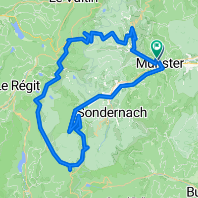
Fr: Münster - Kruth -Münster
- 81.9 km
- 2,306 m
- 2,191 m
- Munster, Grand Est, France
A cycling route starting in Munster, Grand Est, France.
Overview
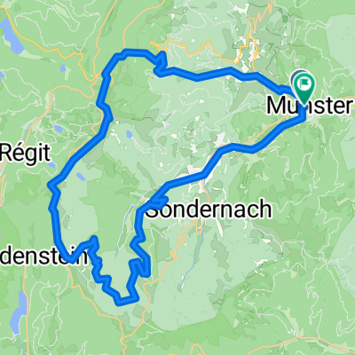
It should be possible to cycle three Ballons in the Vosges in one day, but even without the Petit Ballon, it is hard enough. This tour de force is 153 km long and starts with the steep climb to Col de Platzerwasel (alt. 1186 m) leading to the Route des Crêtes and the Grand Ballon. The latter really only needs to be climbed in the last two kilometers. The descent to Willers-sur-Thurs is particularly challenging: many hairpin turns that are also made of uneven cobblestones. Cramps in the hands from braking are a consequence. The valley you enter is busy with truck traffic. The route quickly curves back inland with a steep climb to the Col de Hundsrück. Don't underestimate it. From Masevaux, the climb to the Ballon d'Alsace starts slowly. The first part can possibly be ridden on the winding bike path of a former railway line. The climb is ultimately a leg-breaker that puts a heavy strain on endurance. Also because the goal is not visible at all. The return journey is somewhat disheartening through industrial valleys and along busy roads. Those who are tired are spared by the relatively quiet climb to the Col de la Schlucht (alt. 1139 m). The long descent is a rewarding reward.
Route quality
Quiet road
24 km
(16 %)
Road
21 km
(14 %)
Paved
100.3 km
(67 %)
Unpaved
3 km
(2 %)
Asphalt
98.8 km
(66 %)
Paved (undefined)
1.5 km
(1 %)
Continue with Bikemap
You would like to ride Fr: Deux Ballons or customize it for your own trip? Here is what you can do with this Bikemap route:
Free trial for 3 days, or one-time payment. More about Bikemap Premium.
Discover more Premium features.
Get Bikemap PremiumFrom our community
Open it in the app