

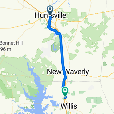
Doge to Riverside 36.5
A cycling route starting in Huntsville, Texas, United States.
Overview
About this route
- 3 h 18 min
- Duration
- 58.7 km
- Distance
- 353 m
- Ascent
- 353 m
- Descent
- 17.8 km/h
- Avg. speed
- 134 m
- Max. altitude
Continue with Bikemap
Use, edit, or download this cycling route
You would like to ride Doge to Riverside 36.5 or customize it for your own trip? Here is what you can do with this Bikemap route:
Free features
- Save this route as favorite or in collections
- Copy & plan your own version of this route
- Sync your route with Garmin or Wahoo
Premium features
Free trial for 3 days, or one-time payment. More about Bikemap Premium.
- Navigate this route on iOS & Android
- Export a GPX / KML file of this route
- Create your custom printout (try it for free)
- Download this route for offline navigation
Discover more Premium features.
Get Bikemap PremiumFrom our community
Other popular routes starting in Huntsville
 Huntsville to Crockett
- Distance
- 85.4 km
- Ascent
- 453 m
- Descent
- 499 m
- Location
- Huntsville, Texas, United States
 SH-75, Huntsville to Calvary Rd, Willis
- Distance
- 36.3 km
- Ascent
- 262 m
- Descent
- 274 m
- Location
- Huntsville, Texas, United States
 FULL Mackey 65
- Distance
- 103.6 km
- Ascent
- 569 m
- Descent
- 570 m
- Location
- Huntsville, Texas, United States
 Doge to Riverside 36.5
- Distance
- 58.7 km
- Ascent
- 353 m
- Descent
- 353 m
- Location
- Huntsville, Texas, United States
 34 Pine Ave, Huntsville to 44 Pine Ave, Huntsville
- Distance
- 25.8 km
- Ascent
- 297 m
- Descent
- 302 m
- Location
- Huntsville, Texas, United States
 Dodge 14.3
- Distance
- 23 km
- Ascent
- 164 m
- Descent
- 167 m
- Location
- Huntsville, Texas, United States
 Short Mackey 28 miles
- Distance
- 44.7 km
- Ascent
- 314 m
- Descent
- 316 m
- Location
- Huntsville, Texas, United States
 PR-40, Huntsville to PR-40, Huntsville
- Distance
- 6.5 km
- Ascent
- 138 m
- Descent
- 134 m
- Location
- Huntsville, Texas, United States
Open it in the app