

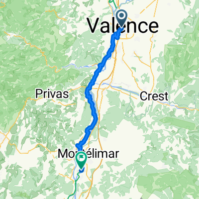
Valence to Lamastre
A cycling route starting in Valence, Auvergne-Rhône-Alpes, France.
Overview
About this route
- 6 h 11 min
- Duration
- 88.8 km
- Distance
- 2,570 m
- Ascent
- 2,322 m
- Descent
- 14.3 km/h
- Avg. speed
- 674 m
- Max. altitude

Route quality
Waytypes & surfaces along the route
Waytypes
Cycleway
32 km
(36 %)
Quiet road
30.2 km
(34 %)
Surfaces
Paved
36.4 km
(41 %)
Unpaved
41.7 km
(47 %)
Asphalt
35.5 km
(40 %)
Gravel
26.6 km
(30 %)
Continue with Bikemap
Use, edit, or download this cycling route
You would like to ride Valence to Lamastre or customize it for your own trip? Here is what you can do with this Bikemap route:
Free features
- Save this route as favorite or in collections
- Copy & plan your own version of this route
- Split it into stages to create a multi-day tour
- Sync your route with Garmin or Wahoo
Premium features
Free trial for 3 days, or one-time payment. More about Bikemap Premium.
- Navigate this route on iOS & Android
- Export a GPX / KML file of this route
- Create your custom printout (try it for free)
- Download this route for offline navigation
Discover more Premium features.
Get Bikemap PremiumFrom our community
Other popular routes starting in Valence
 Valence - Châteauneuf-du-Rhône
- Distance
- 66.9 km
- Ascent
- 254 m
- Descent
- 291 m
- Location
- Valence, Auvergne-Rhône-Alpes, France
 2025 Valence nach Genua
- Distance
- 1,428.2 km
- Ascent
- 14,081 m
- Descent
- 14,183 m
- Location
- Valence, Auvergne-Rhône-Alpes, France
 Soyons - Bourg-Saint-Andéol
- Distance
- 72.1 km
- Ascent
- 266 m
- Descent
- 312 m
- Location
- Valence, Auvergne-Rhône-Alpes, France
 202506 Valence nach Orange
- Distance
- 296.5 km
- Ascent
- 3,858 m
- Descent
- 3,941 m
- Location
- Valence, Auvergne-Rhône-Alpes, France
 Valence Grenoble
- Distance
- 82 km
- Ascent
- 288 m
- Descent
- 228 m
- Location
- Valence, Auvergne-Rhône-Alpes, France
 Route mai 2022 / Drôme et Vaucluse - 1ère partie
- Distance
- 373.6 km
- Ascent
- 5,812 m
- Descent
- 5,869 m
- Location
- Valence, Auvergne-Rhône-Alpes, France
 Valence to Tournon s Rhone
- Distance
- 28.6 km
- Ascent
- 108 m
- Descent
- 94 m
- Location
- Valence, Auvergne-Rhône-Alpes, France
 Allée André Revol nach Rue Pierre Julien
- Distance
- 72.5 km
- Ascent
- 268 m
- Descent
- 286 m
- Location
- Valence, Auvergne-Rhône-Alpes, France
Open it in the app