
Bikeführer MTB "Zur Boyneburg"
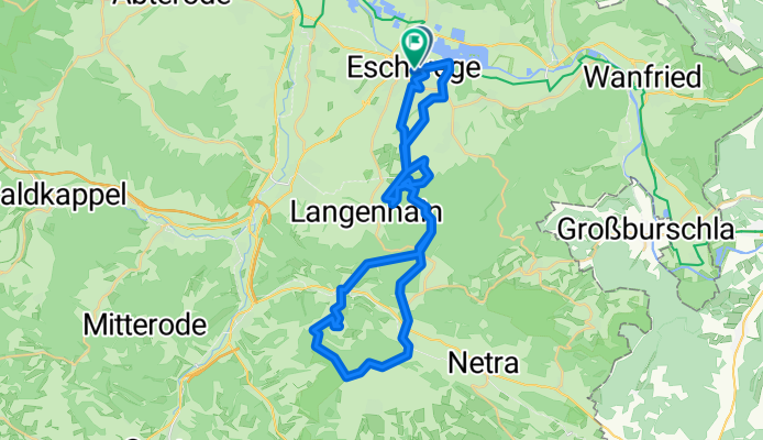
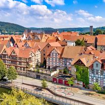
A cycling route starting in Eschwege, Hesse, Germany.
Overview
About this route
medium difficulty mountain bike tour
To Boyneburg
We start at Velo Mangold and cross the road towards Werra. We ride directly upstream along the Werra. After one kilometer, we reach the Felsenkeller and turn right at Zelchersbach. We follow the stream until the path ends. We turn left and follow the signage x5 until we reach a paved road. We keep left and follow the road to the "Regener Hütte". We first turn right and then left after 50 meters. At the edge of the forest, we turn right towards Langenhain and then after several curves in the forest, we return in the direction of the start. After two kilometers, we reach a bend and find a path that leads uphill. We turn right and follow the path until we reach the road. We go about 100 meters to the left and turn right beneath the forest house into the x5. We follow the path to the edge of the forest and now ride straight ahead in the woods. At the next two intersections, we keep left until we reach the Hanrothhütte. We continue left down until we see the barn. We overcome the small obstacle and ride past the barn downhill. Just before the road, a barrier (Caution!) blocks the way, which we pass on the left. We turn right onto the main road and follow it to the intersection with the federal road. We cross the federal road 7 (Caution when crossing!) and ride towards Röhrda. We stay initially on the main road and ride uphill in the village until we come to Aschenborn street. We turn right and follow the road until we turn left into Ditterstal. After 50 meters, we turn left again and follow the x8, which leads us uphill. A steep climb to the Ringgau plateau follows. We reach the height and first ride 200 meters parallel to the main road. We then turn right into the hay path and follow the signage x8 that guides us along the forest edge towards the direction of Boyneburg in the woods. We now turn left onto the hiking trail to Boyneburg. The last section just before the plateau must be done by pushing the bike a few meters. On the plateau, we keep left and ride past the ruins of the castle downhill. After a short descent, the road forks. We follow the sign towards Datterode, which is attached to a beech tree. We continue downhill until we reach a large meadow at the forest edge. On the opposite side, Gut Harmuthshausen can be seen. We turn left and continue downhill in the forest. After a few hundred meters, we leave the forest and first ride a farm road and reach a paved road that we take towards Datterode. In the village, we cross the stream and turn right. We follow the stream for 100 meters and turn left at the Anger. We go uphill now. We cross the main road (Caution!) and follow the path uphill towards mini golf. We leave the village and ride along the paved road past mini golf, initially going uphill in the valley. At the end of the valley, we keep left and ride further uphill, going around some curves. We reach the state road, turn left first and then turn into the second forest road on the right. We now follow the x5 towards Eschwege.
- -:--
- Duration
- 38.8 km
- Distance
- 936 m
- Ascent
- 927 m
- Descent
- ---
- Avg. speed
- 507 m
- Max. altitude

Route quality
Waytypes & surfaces along the route
Waytypes
Track
24.1 km
(62 %)
Quiet road
8.2 km
(21 %)
Surfaces
Paved
9.7 km
(25 %)
Unpaved
22.9 km
(59 %)
Gravel
18.2 km
(47 %)
Asphalt
7.4 km
(19 %)
Continue with Bikemap
Use, edit, or download this cycling route
You would like to ride Bikeführer MTB "Zur Boyneburg" or customize it for your own trip? Here is what you can do with this Bikemap route:
Free features
- Save this route as favorite or in collections
- Copy & plan your own version of this route
- Sync your route with Garmin or Wahoo
Premium features
Free trial for 3 days, or one-time payment. More about Bikemap Premium.
- Navigate this route on iOS & Android
- Export a GPX / KML file of this route
- Create your custom printout (try it for free)
- Download this route for offline navigation
Discover more Premium features.
Get Bikemap PremiumFrom our community
Other popular routes starting in Eschwege
 Bikeführer "Feierabendrunde"
- Distance
- 35.9 km
- Ascent
- 533 m
- Descent
- 533 m
- Location
- Eschwege, Hesse, Germany
 Bikeführer "Im Westerwald"
- Distance
- 50.3 km
- Ascent
- 642 m
- Descent
- 645 m
- Location
- Eschwege, Hesse, Germany
 Hauptstraße 18, Meinhard nach Weserpfad 24, Hann. Münden
- Distance
- 58.2 km
- Ascent
- 385 m
- Descent
- 416 m
- Location
- Eschwege, Hesse, Germany
 Weidenhausen Meinhard "Hessische Schweiz" WTS Home
- Distance
- 30.9 km
- Ascent
- 388 m
- Descent
- 389 m
- Location
- Eschwege, Hesse, Germany
 Wehretal-Melsungen-Sontra
- Distance
- 126.4 km
- Ascent
- 744 m
- Descent
- 744 m
- Location
- Eschwege, Hesse, Germany
 Eschwege-LSZ
- Distance
- 63.4 km
- Ascent
- 635 m
- Descent
- 619 m
- Location
- Eschwege, Hesse, Germany
 Bikeführer "Rund um den Meißner"
- Distance
- 88.7 km
- Ascent
- 655 m
- Descent
- 659 m
- Location
- Eschwege, Hesse, Germany
 Eschwege nach Hann. Münden
- Distance
- 59.4 km
- Ascent
- 565 m
- Descent
- 594 m
- Location
- Eschwege, Hesse, Germany
Open it in the app