Molsheim - Mont Sainte-Odile
A cycling route starting in Ottrott, Grand Est, France.
Overview
About this route
- -:--
- Duration
- 203.9 km
- Distance
- 3,107 m
- Ascent
- 3,675 m
- Descent
- ---
- Avg. speed
- ---
- Max. altitude
Route quality
Waytypes & surfaces along the route
Waytypes
Busy road
172 km
(84 %)
Road
26.1 km
(13 %)
Surfaces
Paved
107.6 km
(53 %)
Unpaved
0.7 km
(<1 %)
Asphalt
107.4 km
(53 %)
Gravel
0.4 km
(<1 %)
Route highlights
Points of interest along the route
Point of interest after 0.9 km
Mont Sainte-Odile
Point of interest after 29 km
Col du Kreuzweg
Point of interest after 47.3 km
Col de Fouchy
Point of interest after 60.9 km
Haut-Koenisgbourg
Point of interest after 89.5 km
Col Haut Ribeauvillé
Point of interest after 103.3 km
Col de Sainte-Marie
Point of interest after 133.3 km
Le Climont
Point of interest after 146.8 km
Col de la Charbonnière
Point of interest after 172.7 km
Kreuzberg
Continue with Bikemap
Use, edit, or download this cycling route
You would like to ride Molsheim - Mont Sainte-Odile or customize it for your own trip? Here is what you can do with this Bikemap route:
Free features
- Save this route as favorite or in collections
- Copy & plan your own version of this route
- Split it into stages to create a multi-day tour
- Sync your route with Garmin or Wahoo
Premium features
Free trial for 3 days, or one-time payment. More about Bikemap Premium.
- Navigate this route on iOS & Android
- Export a GPX / KML file of this route
- Create your custom printout (try it for free)
- Download this route for offline navigation
Discover more Premium features.
Get Bikemap PremiumFrom our community
Other popular routes starting in Ottrott
- Molsheim - Mont Sainte-Odile
- Distance
- 203.9 km
- Ascent
- 3,107 m
- Descent
- 3,675 m
- Location
- Ottrott, Grand Est, France
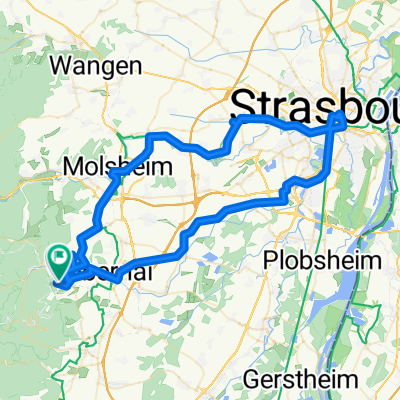
- Ottrott-Strasbourg-Ottrott
- Distance
- 89.9 km
- Ascent
- 435 m
- Descent
- 454 m
- Location
- Ottrott, Grand Est, France
- ottrott 5 sept 10
- Distance
- 50 km
- Ascent
- 1,357 m
- Descent
- 1,348 m
- Location
- Ottrott, Grand Est, France
- Vogesen (Mont Ste.Odile - St.Dié-des-Vosges)
- Distance
- 64.8 km
- Ascent
- 675 m
- Descent
- 1,086 m
- Location
- Ottrott, Grand Est, France
- BTR 2017
- Distance
- 1,099.4 km
- Ascent
- 5,445 m
- Descent
- 5,562 m
- Location
- Ottrott, Grand Est, France
- Niedermünster Rosheim Mollkirch
- Distance
- 20.3 km
- Ascent
- 255 m
- Descent
- 459 m
- Location
- Ottrott, Grand Est, France
- 4. Etappe TransVogesentour
- Distance
- 66 km
- Ascent
- 2,286 m
- Descent
- 2,097 m
- Location
- Ottrott, Grand Est, France
- 1st training
- Distance
- 47.1 km
- Ascent
- 1,211 m
- Descent
- 1,197 m
- Location
- Ottrott, Grand Est, France
Open it in the app