

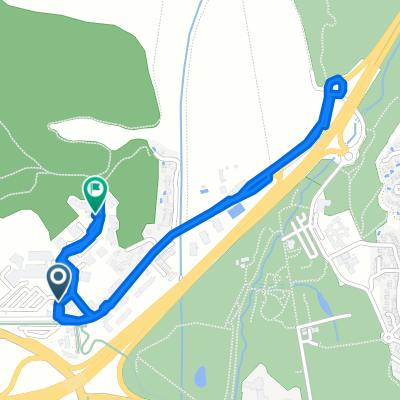
9 Lotissement le Prévert, Saint-Victoret à 10 Lotissement le Prévert, Saint-Victoret
A cycling route starting in Saint-Victoret, Provence-Alpes-Côte d'Azur Region, France.
Overview
About this route
- 50 min
- Duration
- 15.9 km
- Distance
- 200 m
- Ascent
- 198 m
- Descent
- 19.1 km/h
- Avg. speed
- 114 m
- Max. altitude
Route quality
Waytypes & surfaces along the route
Waytypes
Quiet road
6.9 km
(44 %)
Pedestrian area
2.4 km
(15 %)
Surfaces
Paved
0.4 km
(3 %)
Unpaved
1.5 km
(10 %)
Gravel
1.5 km
(10 %)
Asphalt
0.4 km
(3 %)
Undefined
14 km
(88 %)
Continue with Bikemap
Use, edit, or download this cycling route
You would like to ride 9 Lotissement le Prévert, Saint-Victoret à 10 Lotissement le Prévert, Saint-Victoret or customize it for your own trip? Here is what you can do with this Bikemap route:
Free features
- Save this route as favorite or in collections
- Copy & plan your own version of this route
- Sync your route with Garmin or Wahoo
Premium features
Free trial for 3 days, or one-time payment. More about Bikemap Premium.
- Navigate this route on iOS & Android
- Export a GPX / KML file of this route
- Create your custom printout (try it for free)
- Download this route for offline navigation
Discover more Premium features.
Get Bikemap PremiumFrom our community
Other popular routes starting in Saint-Victoret
 De Allée Albert Einstein, Vitrolles à 23 Allee Albert Einstein, Vitrolles
- Distance
- 2.9 km
- Ascent
- 46 m
- Descent
- 33 m
- Location
- Saint-Victoret, Provence-Alpes-Côte d'Azur Region, France
 Noel?
Noel?- Distance
- 277.2 km
- Ascent
- 1,263 m
- Descent
- 1,307 m
- Location
- Saint-Victoret, Provence-Alpes-Côte d'Azur Region, France
 De D20, Vitrolles à Chemin Mireille 100, Salon-de-Provence
- Distance
- 37.6 km
- Ascent
- 392 m
- Descent
- 317 m
- Location
- Saint-Victoret, Provence-Alpes-Côte d'Azur Region, France
 Vliegveld_Aix en Provence
- Distance
- 25.5 km
- Ascent
- 331 m
- Descent
- 166 m
- Location
- Saint-Victoret, Provence-Alpes-Côte d'Azur Region, France
 Marseille-Bilbao_01
- Distance
- 889.9 km
- Ascent
- 992 m
- Descent
- 984 m
- Location
- Saint-Victoret, Provence-Alpes-Côte d'Azur Region, France
 Noel2?
- Distance
- 298.5 km
- Ascent
- 456 m
- Descent
- 508 m
- Location
- Saint-Victoret, Provence-Alpes-Côte d'Azur Region, France
 Day 1 Arles
- Distance
- 58.9 km
- Ascent
- 15 m
- Descent
- 19 m
- Location
- Saint-Victoret, Provence-Alpes-Côte d'Azur Region, France
 balade
- Distance
- 14.4 km
- Ascent
- 175 m
- Descent
- 180 m
- Location
- Saint-Victoret, Provence-Alpes-Côte d'Azur Region, France
Open it in the app