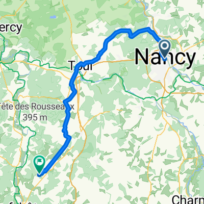
D3_Nancy to Xouaxange
A cycling route starting in Nancy, Alsace-Champagne-Ardenne-Lorraine, France.
Overview
About this route
- 4 h
- Duration
- 73.5 km
- Distance
- 231 m
- Ascent
- 156 m
- Descent
- 18.4 km/h
- Avg. speed
- 286 m
- Avg. speed
Route quality
Waytypes & surfaces along the route
Waytypes
Path
46.5 km
(63 %)
Cycleway
6.7 km
(9 %)
Surfaces
Paved
52.9 km
(72 %)
Unpaved
4 km
(5 %)
Asphalt
52.9 km
(72 %)
Loose gravel
3.7 km
(5 %)
Continue with Bikemap
Use, edit, or download this cycling route
You would like to ride D3_Nancy to Xouaxange or customize it for your own trip? Here is what you can do with this Bikemap route:
Free features
- Save this route as favorite or in collections
- Copy & plan your own version of this route
- Sync your route with Garmin or Wahoo
Premium features
Free trial for 3 days, or one-time payment. More about Bikemap Premium.
- Navigate this route on iOS & Android
- Export a GPX / KML file of this route
- Create your custom printout (try it for free)
- Download this route for offline navigation
Discover more Premium features.
Get Bikemap PremiumFrom our community
Other popular routes starting in Nancy
- 4 Tour de France - Nancy _ Chaumont
- Distance
- 119.2 km
- Ascent
- 715 m
- Descent
- 604 m
- Location
- Nancy, Alsace-Champagne-Ardenne-Lorraine, France
- 80 km autour de nancy
- Distance
- 86.9 km
- Ascent
- 234 m
- Descent
- 237 m
- Location
- Nancy, Alsace-Champagne-Ardenne-Lorraine, France
- FR1 6: Nancy - Golbey; 73,3km 150hm
- Distance
- 73.3 km
- Ascent
- 238 m
- Descent
- 124 m
- Location
- Nancy, Alsace-Champagne-Ardenne-Lorraine, France
- Blénod - Pagny la Blanche Côte - Pagny sur Meuse
- Distance
- 119.3 km
- Ascent
- 1,289 m
- Descent
- 1,288 m
- Location
- Nancy, Alsace-Champagne-Ardenne-Lorraine, France
- 2015 Nancy - Bretagne - Belgien - Holland
- Distance
- 1,528.4 km
- Ascent
- 825 m
- Descent
- 1,036 m
- Location
- Nancy, Alsace-Champagne-Ardenne-Lorraine, France
- Gravel Côte de Toul
- Distance
- 75.5 km
- Ascent
- 1,024 m
- Descent
- 1,019 m
- Location
- Nancy, Alsace-Champagne-Ardenne-Lorraine, France
- Entre le Massif de Haye et la Moselle
- Distance
- 56.8 km
- Ascent
- 672 m
- Descent
- 664 m
- Location
- Nancy, Alsace-Champagne-Ardenne-Lorraine, France
- Gravel Moselle - Griscourt - Blanzey
- Distance
- 90.3 km
- Ascent
- 1,212 m
- Descent
- 1,194 m
- Location
- Nancy, Alsace-Champagne-Ardenne-Lorraine, France
Open it in the app