

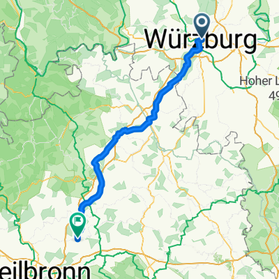
Romantische Strasse: Würzburg - Augsburg
A cycling route starting in Wurzburg, Bavaria, Germany.
Overview
About this route
18.04 - 21.04.2025
- -:--
- Duration
- 360 km
- Distance
- 2,171 m
- Ascent
- 1,853 m
- Descent
- ---
- Avg. speed
- 536 m
- Max. altitude

Continue with Bikemap
Use, edit, or download this cycling route
You would like to ride Romantische Strasse: Würzburg - Augsburg or customize it for your own trip? Here is what you can do with this Bikemap route:
Free features
- Save this route as favorite or in collections
- Copy & plan your own version of this route
- Split it into stages to create a multi-day tour
- Sync your route with Garmin or Wahoo
Premium features
Free trial for 3 days, or one-time payment. More about Bikemap Premium.
- Navigate this route on iOS & Android
- Export a GPX / KML file of this route
- Create your custom printout (try it for free)
- Download this route for offline navigation
Discover more Premium features.
Get Bikemap PremiumFrom our community
Other popular routes starting in Wurzburg
 Wü-Dett-Kt-Och-Eich Och Wü
- Distance
- 77.7 km
- Ascent
- 354 m
- Descent
- 354 m
- Location
- Wurzburg, Bavaria, Germany
 Würzburg über Winterhausen, Albertshausen
- Distance
- 33.2 km
- Ascent
- 188 m
- Descent
- 189 m
- Location
- Wurzburg, Bavaria, Germany
 Würzburg Kochersteinsfeld wie outdooractive - e Bike
- Distance
- 95.8 km
- Ascent
- 1,644 m
- Descent
- 1,635 m
- Location
- Wurzburg, Bavaria, Germany
 Rückermainstraße, Würzburg to Place de la Palud, Lausanne
- Distance
- 627.9 km
- Ascent
- 6,215 m
- Descent
- 5,892 m
- Location
- Wurzburg, Bavaria, Germany
 Würzburg Kochersteinsfeld über Ochsenfurt -ausgeglichen
- Distance
- 121.1 km
- Ascent
- 1,430 m
- Descent
- 1,418 m
- Location
- Wurzburg, Bavaria, Germany
 Würzburg nach Kochersteinsfeld Import aus Komoot
- Distance
- 96.8 km
- Ascent
- 1,027 m
- Descent
- 1,016 m
- Location
- Wurzburg, Bavaria, Germany
 Steinbachtal-H'berg-Waldbüttelbrunn-H'berg-Steinbachtal
- Distance
- 16.9 km
- Ascent
- 239 m
- Descent
- 236 m
- Location
- Wurzburg, Bavaria, Germany
 Runde Höhenweg Wü Richtung Och 12xxhm
- Distance
- 56.1 km
- Ascent
- 784 m
- Descent
- 784 m
- Location
- Wurzburg, Bavaria, Germany
Open it in the app