

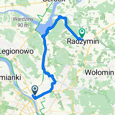
Warsaw to Radzymin
A cycling route starting in Żoliborz, Masovian Voivodeship, Poland.
Overview
About this route
- 2 h 27 min
- Duration
- 41.9 km
- Distance
- 52 m
- Ascent
- 46 m
- Descent
- 17.1 km/h
- Avg. speed
- 90 m
- Max. altitude

Route quality
Waytypes & surfaces along the route
Waytypes
Cycleway
18.4 km
(44 %)
Quiet road
10.9 km
(26 %)
Surfaces
Paved
35.5 km
(85 %)
Unpaved
0.4 km
(<1 %)
Asphalt
32.9 km
(79 %)
Paved (undefined)
1.5 km
(3 %)
Continue with Bikemap
Use, edit, or download this cycling route
You would like to ride Warsaw to Radzymin or customize it for your own trip? Here is what you can do with this Bikemap route:
Free features
- Save this route as favorite or in collections
- Copy & plan your own version of this route
- Sync your route with Garmin or Wahoo
Premium features
Free trial for 3 days, or one-time payment. More about Bikemap Premium.
- Navigate this route on iOS & Android
- Export a GPX / KML file of this route
- Create your custom printout (try it for free)
- Download this route for offline navigation
Discover more Premium features.
Get Bikemap PremiumFrom our community
Other popular routes starting in Żoliborz
 05. Rondo Babka (sobotnia i poza sezonem - krótka)
- Distance
- 65.1 km
- Ascent
- 40 m
- Descent
- 60 m
- Location
- Żoliborz, Masovian Voivodeship, Poland
 Zygmunta Krasińskiego 34A do Rudzka
- Distance
- 2.4 km
- Ascent
- 0 m
- Descent
- 22 m
- Location
- Żoliborz, Masovian Voivodeship, Poland
 Dębe - Serock - Wyszków
- Distance
- 147.9 km
- Ascent
- 107 m
- Descent
- 106 m
- Location
- Żoliborz, Masovian Voivodeship, Poland
 Warsaw to Radzymin
- Distance
- 41.9 km
- Ascent
- 52 m
- Descent
- 46 m
- Location
- Żoliborz, Masovian Voivodeship, Poland
 Zygmunta Krasińskiego 63A, Warszawa do Powązkowska 44B, Warszawa
- Distance
- 15.9 km
- Ascent
- 88 m
- Descent
- 88 m
- Location
- Żoliborz, Masovian Voivodeship, Poland
 Wielki Żoliborz
- Distance
- 30 km
- Ascent
- 79 m
- Descent
- 79 m
- Location
- Żoliborz, Masovian Voivodeship, Poland
 Warszawa-Warsaw best of
- Distance
- 23.2 km
- Ascent
- 71 m
- Descent
- 69 m
- Location
- Żoliborz, Masovian Voivodeship, Poland
 🇵🇱 Warszawa - Ostrów Maz. (171km)
- Distance
- 235.1 km
- Ascent
- 149 m
- Descent
- 147 m
- Location
- Żoliborz, Masovian Voivodeship, Poland
Open it in the app