
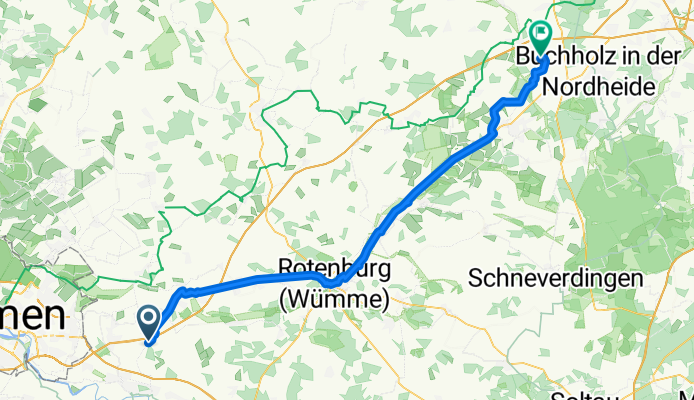
Borsteler Straße 58, Oyten nach Beim Alten Hof 1, Wenzendorf
A cycling route starting in Oyten, Lower Saxony, Germany.
Overview
About this route
- 3 h 24 min
- Duration
- 70 km
- Distance
- 608 m
- Ascent
- 573 m
- Descent
- 20.6 km/h
- Avg. speed
- 68 m
- Max. altitude
Route quality
Waytypes & surfaces along the route
Waytypes
Cycleway
29.5 km
(42 %)
Quiet road
15.4 km
(22 %)
Surfaces
Paved
42.3 km
(60 %)
Unpaved
2.1 km
(3 %)
Asphalt
36.2 km
(52 %)
Paved (undefined)
4.1 km
(6 %)
Continue with Bikemap
Use, edit, or download this cycling route
You would like to ride Borsteler Straße 58, Oyten nach Beim Alten Hof 1, Wenzendorf or customize it for your own trip? Here is what you can do with this Bikemap route:
Free features
- Save this route as favorite or in collections
- Copy & plan your own version of this route
- Sync your route with Garmin or Wahoo
Premium features
Free trial for 3 days, or one-time payment. More about Bikemap Premium.
- Navigate this route on iOS & Android
- Export a GPX / KML file of this route
- Create your custom printout (try it for free)
- Download this route for offline navigation
Discover more Premium features.
Get Bikemap PremiumFrom our community
Other popular routes starting in Oyten
 Verdenrunde Rev.1
- Distance
- 62.2 km
- Ascent
- 94 m
- Descent
- 94 m
- Location
- Oyten, Lower Saxony, Germany
 Rund um die Borgfelder und Fischerhuder Wümmewiesen
- Distance
- 42.2 km
- Ascent
- 20 m
- Descent
- 21 m
- Location
- Oyten, Lower Saxony, Germany
 Wümme-Radweg (regional)
- Distance
- 57.6 km
- Ascent
- 98 m
- Descent
- 100 m
- Location
- Oyten, Lower Saxony, Germany
 Epp.-Bollen-Achim-Uelsen-Grasdorf-Bassen-Sagehorn
- Distance
- 55.3 km
- Ascent
- 42 m
- Descent
- 45 m
- Location
- Oyten, Lower Saxony, Germany
 Recovered Route
- Distance
- 45.8 km
- Ascent
- 298 m
- Descent
- 283 m
- Location
- Oyten, Lower Saxony, Germany
 Lindenstraße 4, Oyten do Lindenstraße 4, Oyten
- Distance
- 13.4 km
- Ascent
- 24 m
- Descent
- 27 m
- Location
- Oyten, Lower Saxony, Germany
 80km über die Dörfer
- Distance
- 80.1 km
- Ascent
- 123 m
- Descent
- 124 m
- Location
- Oyten, Lower Saxony, Germany
 Mountie-Grundstrecke-Tennispark
- Distance
- 17 km
- Ascent
- 50 m
- Descent
- 50 m
- Location
- Oyten, Lower Saxony, Germany
Open it in the app