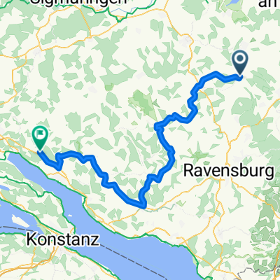
Aulendorf - Bodensee - Rheinfall - Tübingen
A cycling route starting in Aulendorf, Baden-Württemberg, Germany.
Overview
About this route
- 15 h 31 min
- Duration
- 268.6 km
- Distance
- 2,958 m
- Ascent
- 3,155 m
- Descent
- 17.3 km/h
- Avg. speed
- 768 m
- Avg. speed
Route quality
Waytypes & surfaces along the route
Waytypes
Path
89.7 km
(33 %)
Quiet road
76.4 km
(28 %)
Surfaces
Paved
231.3 km
(86 %)
Unpaved
13.1 km
(5 %)
Asphalt
221.6 km
(82 %)
Gravel
10.7 km
(4 %)
Continue with Bikemap
Use, edit, or download this cycling route
You would like to ride Aulendorf - Bodensee - Rheinfall - Tübingen or customize it for your own trip? Here is what you can do with this Bikemap route:
Free features
- Save this route as favorite or in collections
- Copy & plan your own version of this route
- Sync your route with Garmin or Wahoo
Premium features
Free trial for 3 days, or one-time payment. More about Bikemap Premium.
- Navigate this route on iOS & Android
- Export a GPX / KML file of this route
- Create your custom printout (try it for free)
- Download this route for offline navigation
Discover more Premium features.
Get Bikemap PremiumFrom our community
Other popular routes starting in Aulendorf
- Hatzenturm, Vorsee, Altshausen, Baltshaus, Geigelbach
- Distance
- 34.3 km
- Ascent
- 246 m
- Descent
- 247 m
- Location
- Aulendorf, Baden-Württemberg, Germany
- Woche 1 Steege
- Distance
- 5.5 km
- Ascent
- 46 m
- Descent
- 49 m
- Location
- Aulendorf, Baden-Württemberg, Germany
- Aulendorf - Markdorf über Fronreute - Horgenzell - Hefigkofen
- Distance
- 44.4 km
- Ascent
- 286 m
- Descent
- 428 m
- Location
- Aulendorf, Baden-Württemberg, Germany
- leider mit Steigung :-)
- Distance
- 2.4 km
- Ascent
- 118 m
- Descent
- 101 m
- Location
- Aulendorf, Baden-Württemberg, Germany
- Allgäu - Oberschwaben Bäder-Rundtour
- Distance
- 56.3 km
- Ascent
- 577 m
- Descent
- 575 m
- Location
- Aulendorf, Baden-Württemberg, Germany
- Elchenreute Baienfurt Elchenreute
- Distance
- 19.6 km
- Ascent
- 89 m
- Descent
- 191 m
- Location
- Aulendorf, Baden-Württemberg, Germany
- Aulendorfer Runde
- Distance
- 53.8 km
- Ascent
- 526 m
- Descent
- 486 m
- Location
- Aulendorf, Baden-Württemberg, Germany
- Unbenannte Route
- Distance
- 68 km
- Ascent
- 1,189 m
- Descent
- 1,350 m
- Location
- Aulendorf, Baden-Württemberg, Germany
Open it in the app