

Oberharz-Tour
A cycling route starting in Harsleben, Saxony-Anhalt, Germany.
Overview
About this route
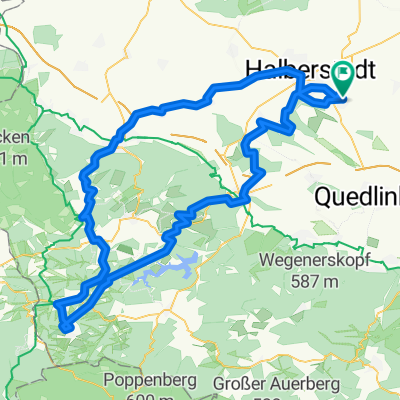
Kurz nach 9 Uhr gestartet, geht es über Westerhausen, Börnicke, Blankenburg und Heimburg in den Harz.
Das Trektal hinauf, führt die Tour weiter über Elbingerode und dann immer die B27 durch Braunlage Richtung Sösetalsperre.
Nach 3-4 km Abfahrt geht es rechts weg auf der L519 über St.Andreasberg nach Sonnenberg wieder ca. 400m aufwärts.
Auf der B242 fahren wir weiter durch Clausthal-Zellerfeld bis zum Abzweig Wildemann und Lautenthal nach Langelsheim die Innerste hinunter.
Über Astfeld, Goslar, Oker und Göttingerode führt uns der Weg nach Bad Harzburg.
Stapelburg, Schauen, Berßel, Wasserleben, Langeln, Heudeber, Danstedt, Ströbeck und Halberstadt sind weitere Stationen ans Ziel.
- -:--
- Duration
- 183.7 km
- Distance
- 990 m
- Ascent
- 990 m
- Descent
- ---
- Avg. speed
- ---
- Max. altitude

Route quality
Waytypes & surfaces along the route
Waytypes
Busy road
69.6 km
(38 %)
Road
40.7 km
(22 %)
Surfaces
Paved
140.7 km
(77 %)
Unpaved
7.7 km
(4 %)
Asphalt
127.7 km
(69 %)
Paving stones
4.7 km
(3 %)
Route highlights
Points of interest along the route
Point of interest after 58.1 km
Von hier an ca. 400m Höhe bis Sonnenberg
Point of interest after 90 km
Jetzt geht es nur noch bergab und das meist mit Rückenwind, bis hierhin nur Gegenwind
Point of interest after 103.9 km
Mit Kaffee und Kuchen eine kleine Stärkung und dann Nonstop nach Haus ( ca. 80 km )
Continue with Bikemap
Use, edit, or download this cycling route
You would like to ride Oberharz-Tour or customize it for your own trip? Here is what you can do with this Bikemap route:
Free features
- Save this route as favorite or in collections
- Copy & plan your own version of this route
- Split it into stages to create a multi-day tour
- Sync your route with Garmin or Wahoo
Premium features
Free trial for 3 days, or one-time payment. More about Bikemap Premium.
- Navigate this route on iOS & Android
- Export a GPX / KML file of this route
- Create your custom printout (try it for free)
- Download this route for offline navigation
Discover more Premium features.
Get Bikemap PremiumFrom our community
Other popular routes starting in Harsleben
 Unterharz - Tour
- Distance
- 102.5 km
- Ascent
- 651 m
- Descent
- 650 m
- Location
- Harsleben, Saxony-Anhalt, Germany
 Ostharz von Selke bis Bode
- Distance
- 116.6 km
- Ascent
- 913 m
- Descent
- 911 m
- Location
- Harsleben, Saxony-Anhalt, Germany
 Brocken und Huy
- Distance
- 150.7 km
- Ascent
- 1,103 m
- Descent
- 1,100 m
- Location
- Harsleben, Saxony-Anhalt, Germany
 Hängebrücke auf Umwegen
- Distance
- 133.2 km
- Ascent
- 858 m
- Descent
- 858 m
- Location
- Harsleben, Saxony-Anhalt, Germany
 Transall - Ballenstedt
- Distance
- 98.1 km
- Ascent
- 577 m
- Descent
- 577 m
- Location
- Harsleben, Saxony-Anhalt, Germany
 Oberharz-Tour
- Distance
- 183.7 km
- Ascent
- 990 m
- Descent
- 990 m
- Location
- Harsleben, Saxony-Anhalt, Germany
 Kaffeefahrt zur Roten Mühle
- Distance
- 64.9 km
- Ascent
- 493 m
- Descent
- 497 m
- Location
- Harsleben, Saxony-Anhalt, Germany
 Die Lange
- Distance
- 111.7 km
- Ascent
- 728 m
- Descent
- 727 m
- Location
- Harsleben, Saxony-Anhalt, Germany
Open it in the app