

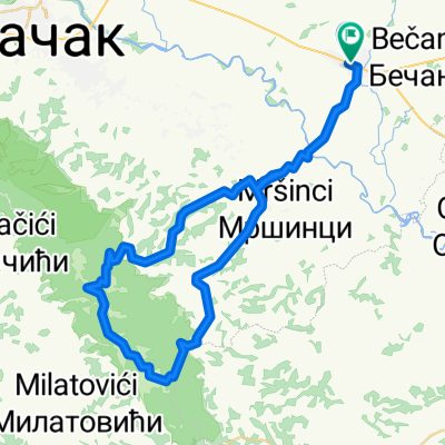
Čačak-Koštunići-Tometino polje-Čačak
A cycling route starting in Čačak, Central Serbia, Serbia.
Overview
About this route
Asfalt, makadam, planinski putevi, lepipejzaži
- -:--
- Duration
- 95.4 km
- Distance
- 871 m
- Ascent
- 871 m
- Descent
- ---
- Avg. speed
- ---
- Max. altitude

Route quality
Waytypes & surfaces along the route
Waytypes
Quiet road
44.8 km
(47 %)
Track
15.3 km
(16 %)
Surfaces
Paved
59.1 km
(62 %)
Unpaved
19.1 km
(20 %)
Asphalt
54.4 km
(57 %)
Gravel
18.1 km
(19 %)
Continue with Bikemap
Use, edit, or download this cycling route
You would like to ride Čačak-Koštunići-Tometino polje-Čačak or customize it for your own trip? Here is what you can do with this Bikemap route:
Free features
- Save this route as favorite or in collections
- Copy & plan your own version of this route
- Split it into stages to create a multi-day tour
- Sync your route with Garmin or Wahoo
Premium features
Free trial for 3 days, or one-time payment. More about Bikemap Premium.
- Navigate this route on iOS & Android
- Export a GPX / KML file of this route
- Create your custom printout (try it for free)
- Download this route for offline navigation
Discover more Premium features.
Get Bikemap PremiumFrom our community
Other popular routes starting in Čačak
 Vranic - veliki krug
- Distance
- 9 km
- Ascent
- 139 m
- Descent
- 126 m
- Location
- Čačak, Central Serbia, Serbia
 Mrcajevci-Torlak-Brezovice-Kaona-Mrcajevci
- Distance
- 74.2 km
- Ascent
- 755 m
- Descent
- 755 m
- Location
- Čačak, Central Serbia, Serbia
 Transverzala
- Distance
- 33.8 km
- Ascent
- 324 m
- Descent
- 326 m
- Location
- Čačak, Central Serbia, Serbia
 mrcajevci-atenica-vrhom jelice -mrcajevci
- Distance
- 57.7 km
- Ascent
- 764 m
- Descent
- 768 m
- Location
- Čačak, Central Serbia, Serbia
 Cacak-Cekovic
- Distance
- 51.6 km
- Ascent
- 342 m
- Descent
- 344 m
- Location
- Čačak, Central Serbia, Serbia
 Cack-Slatinska banja-Samaila-Cacak
- Distance
- 56.3 km
- Ascent
- 200 m
- Descent
- 201 m
- Location
- Čačak, Central Serbia, Serbia
 Mrcajevci-Torlak-Brezovice-Mrcajevci
- Distance
- 49.3 km
- Ascent
- 717 m
- Descent
- 716 m
- Location
- Čačak, Central Serbia, Serbia
 Cacak-Srezojeci-Kostunici-Miokovci-Cacak
- Distance
- 66.2 km
- Ascent
- 567 m
- Descent
- 565 m
- Location
- Čačak, Central Serbia, Serbia
Open it in the app