
dk-Mountainbike 1
- 9.4 km
- 282 m
- 282 m
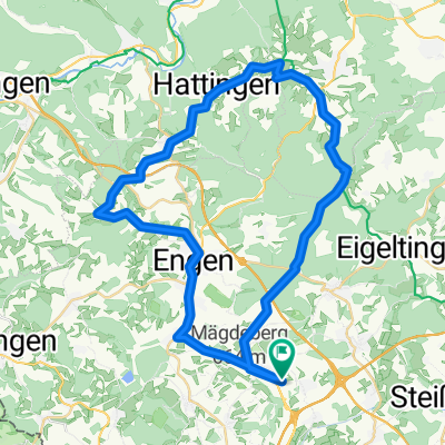
- Mühlhausen-Ehingen, Baden-Wurttemberg, Germany
A cycling route starting in Mühlhausen-Ehingen, Baden-Wurttemberg, Germany.
Overview
From Ehingen via Mühlhausen, Mägdeberg, Duchtlingen, Katzental to Gottmadingen. The route runs on secondary roads and should feature little motor traffic. To cross the Mägdeberg from Mühlhausen to Duchtlingen, there is about 2 km of steep uphill, and on the other side, it descends over the same distance. The rest of the route is rather flat to hilly. The route mainly runs between fields and meadows, with short stretches through or alongside woods.
created this 13 years ago
Route quality
Quiet road
11.2 km
(87 %)
Track
1.4 km
(11 %)
Paved
12 km
(93 %)
Unpaved
0.5 km
(4 %)
Asphalt
11.1 km
(86 %)
Paved (undefined)
0.9 km
(7 %)
Continue with Bikemap
You would like to ride Mühlhausen-Ehingen n. Gottmadingen - Route 1 or customize it for your own trip? Here is what you can do with this Bikemap route:
Free trial for 3 days, or one-time payment. More about Bikemap Premium.
Discover more Premium features.
Get Bikemap PremiumFrom our community
Open it in the app