

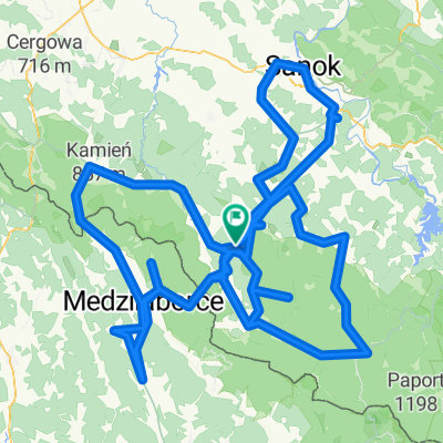
87A, Komańcza do Droga Wojewódzka 897 159
A cycling route starting in Komańcza, Subcarpathian Voivodeship, Poland.
Overview
About this route
- 5 h 19 min
- Duration
- 57.7 km
- Distance
- 1,414 m
- Ascent
- 1,408 m
- Descent
- 10.8 km/h
- Avg. speed
- 958 m
- Max. altitude

Route quality
Waytypes & surfaces along the route
Waytypes
Quiet road
13.8 km
(24 %)
Track
13.8 km
(24 %)
Surfaces
Paved
41.5 km
(72 %)
Unpaved
13.8 km
(24 %)
Asphalt
41 km
(71 %)
Ground
12.1 km
(21 %)
Continue with Bikemap
Use, edit, or download this cycling route
You would like to ride 87A, Komańcza do Droga Wojewódzka 897 159 or customize it for your own trip? Here is what you can do with this Bikemap route:
Free features
- Save this route as favorite or in collections
- Copy & plan your own version of this route
- Sync your route with Garmin or Wahoo
Premium features
Free trial for 3 days, or one-time payment. More about Bikemap Premium.
- Navigate this route on iOS & Android
- Export a GPX / KML file of this route
- Create your custom printout (try it for free)
- Download this route for offline navigation
Discover more Premium features.
Get Bikemap PremiumFrom our community
Other popular routes starting in Komańcza
 Dookoła Polski 4 dzień (Komańcza-Wawrzka)
- Distance
- 114 km
- Ascent
- 946 m
- Descent
- 887 m
- Location
- Komańcza, Subcarpathian Voivodeship, Poland
 Okolice Komańczy
- Distance
- 370.1 km
- Ascent
- 5,593 m
- Descent
- 5,592 m
- Location
- Komańcza, Subcarpathian Voivodeship, Poland
 Lyžiarsky pochod Palota-Habura
- Distance
- 19.3 km
- Ascent
- 442 m
- Descent
- 749 m
- Location
- Komańcza, Subcarpathian Voivodeship, Poland
 Smolnik - Cisna MTB jesień
- Distance
- 27 km
- Ascent
- 665 m
- Descent
- 624 m
- Location
- Komańcza, Subcarpathian Voivodeship, Poland
 wislok 200
- Distance
- 222.8 km
- Ascent
- 211 m
- Descent
- 597 m
- Location
- Komańcza, Subcarpathian Voivodeship, Poland
 Łupków -Wołkowyja
- Distance
- 45.7 km
- Ascent
- 351 m
- Descent
- 526 m
- Location
- Komańcza, Subcarpathian Voivodeship, Poland
 87A, Komańcza do Droga Wojewódzka 897 159
- Distance
- 57.7 km
- Ascent
- 1,414 m
- Descent
- 1,408 m
- Location
- Komańcza, Subcarpathian Voivodeship, Poland
 Rowerowa Wyprawa Bieszczadzka 2-5.08.2013 - dzień 2
- Distance
- 46.8 km
- Ascent
- 1,231 m
- Descent
- 1,117 m
- Location
- Komańcza, Subcarpathian Voivodeship, Poland
Open it in the app