

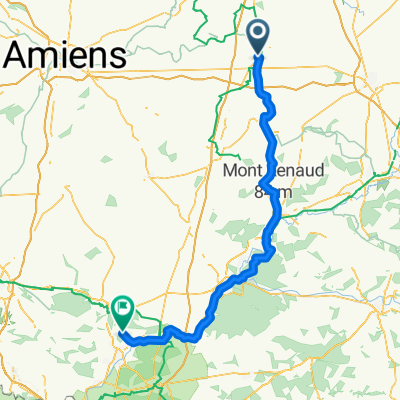
Untitled route
A cycling route starting in Péronne, Hauts-de-France, France.
Overview
About this route
- 3 h
- Duration
- 44.3 km
- Distance
- 313 m
- Ascent
- 314 m
- Descent
- 14.8 km/h
- Avg. speed
- 88 m
- Max. altitude

Route quality
Waytypes & surfaces along the route
Waytypes
Quiet road
19.9 km
(45 %)
Access road
15.9 km
(36 %)
Surfaces
Paved
4.9 km
(11 %)
Asphalt
2.7 km
(6 %)
Paved (undefined)
2.2 km
(5 %)
Undefined
39.4 km
(89 %)
Continue with Bikemap
Use, edit, or download this cycling route
You would like to ride Untitled route or customize it for your own trip? Here is what you can do with this Bikemap route:
Free features
- Save this route as favorite or in collections
- Copy & plan your own version of this route
- Sync your route with Garmin or Wahoo
Premium features
Free trial for 3 days, or one-time payment. More about Bikemap Premium.
- Navigate this route on iOS & Android
- Export a GPX / KML file of this route
- Create your custom printout (try it for free)
- Download this route for offline navigation
Discover more Premium features.
Get Bikemap PremiumFrom our community
Other popular routes starting in Péronne
 From Feuillères to Paris
- Distance
- 112 km
- Ascent
- 407 m
- Descent
- 364 m
- Location
- Péronne, Hauts-de-France, France
 6 peronne naar soissons
- Distance
- 110.9 km
- Ascent
- 297 m
- Descent
- 306 m
- Location
- Péronne, Hauts-de-France, France
 LILLE PARIS J2 - Bapaume - Lacroix-Saint-Ouen
- Distance
- 120.6 km
- Ascent
- 536 m
- Descent
- 530 m
- Location
- Péronne, Hauts-de-France, France
 J002 - 1er Juin - Péronne to Clermont (ok)
- Distance
- 83.9 km
- Ascent
- 240 m
- Descent
- 200 m
- Location
- Péronne, Hauts-de-France, France
 Day 38 Peronne - Champs Elysees
- Distance
- 137.9 km
- Ascent
- 331 m
- Descent
- 345 m
- Location
- Péronne, Hauts-de-France, France
 De Rue Wolfgang Amadeus Mozart 16, Péronne à Rue Wolfgang Amadeus Mozart 16, Péronne
- Distance
- 14.1 km
- Ascent
- 114 m
- Descent
- 126 m
- Location
- Péronne, Hauts-de-France, France
 Péronne - Cambrai
- Distance
- 35.1 km
- Ascent
- 197 m
- Descent
- 175 m
- Location
- Péronne, Hauts-de-France, France
 siste 2 etappene av turen
- Distance
- 134 km
- Ascent
- 309 m
- Descent
- 343 m
- Location
- Péronne, Hauts-de-France, France
Open it in the app