

Trailforks Route Plan - Trailforks Route Plan
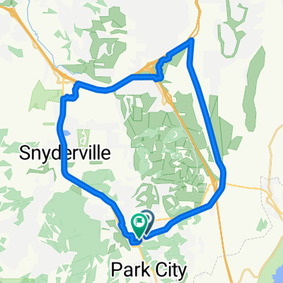
A cycling route starting in Park City, Utah, United States.
Overview
About this route
- 2 h 16 min
- Duration
- 27.9 km
- Distance
- 592 m
- Ascent
- 586 m
- Descent
- 12.3 km/h
- Avg. speed
- 2,173 m
- Max. altitude
Shane K

created this 7 months ago
Route quality
Waytypes & surfaces along the route
Waytypes
Path
15.1 km
(54 %)
Quiet road
0.3 km
(1 %)
Undefined
12.5 km
(45 %)
Surfaces
Unpaved
15.1 km
(54 %)
Ground
14.8 km
(53 %)
Gravel
0.3 km
(1 %)
Undefined
12.8 km
(46 %)
Continue with Bikemap
Use, edit, or download this cycling route
You would like to ride Trailforks Route Plan - Trailforks Route Plan or customize it for your own trip? Here is what you can do with this Bikemap route:
Free features
- Save this route as favorite or in collections
- Copy & plan your own version of this route
- Sync your route with Garmin or Wahoo
Premium features
Free trial for 3 days, or one-time payment. More about Bikemap Premium.
- Navigate this route on iOS & Android
- Export a GPX / KML file of this route
- Create your custom printout (try it for free)
- Download this route for offline navigation
Discover more Premium features.
Get Bikemap PremiumFrom our community
Other popular routes starting in Park City
- 8304 S Brighton Loop Rd, Brighton a 10043–10099 E Big Cottonwood Canyon Rd, Brighton
- 12.4 km
- 450 m
- 686 m
- Park City, Utah, United States
- Union Pacific Rail Trail, Park City to Union Pacific Rail Trail, Park City
- 28.8 km
- 197 m
- 197 m
- Park City, Utah, United States
- wasatch crest trail
- 15.7 km
- 424 m
- 864 m
- Park City, Utah, United States
- Bonanza Dr, Park City to Bonanza Dr, Park City
- 31.1 km
- 230 m
- 230 m
- Park City, Utah, United States
- big bike mike day bikes x2
- 110.6 km
- 1,925 m
- 1,955 m
- Park City, Utah, United States
- Restful route in Park City
- 26.2 km
- 279 m
- 289 m
- Park City, Utah, United States


Open it in the app