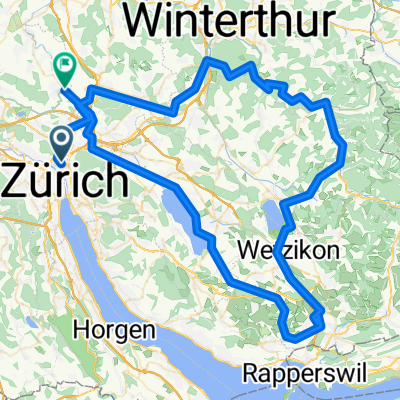
Fyrabig-Tour-West
A cycling route starting in Zürich (Kreis 6) / Unterstrass, Canton of Zurich, Switzerland.
Overview
About this route
Kurze Tour mit einer leichten Steigung
- -:--
- Duration
- 19.4 km
- Distance
- 210 m
- Ascent
- 188 m
- Descent
- ---
- Avg. speed
- 539 m
- Max. altitude
Route quality
Waytypes & surfaces along the route
Waytypes
Road
7.2 km
(37 %)
Path
2.9 km
(15 %)
Surfaces
Paved
19.2 km
(99 %)
Asphalt
19.2 km
(99 %)
Undefined
0.2 km
(1 %)
Continue with Bikemap
Use, edit, or download this cycling route
You would like to ride Fyrabig-Tour-West or customize it for your own trip? Here is what you can do with this Bikemap route:
Free features
- Save this route as favorite or in collections
- Copy & plan your own version of this route
- Sync your route with Garmin or Wahoo
Premium features
Free trial for 3 days, or one-time payment. More about Bikemap Premium.
- Navigate this route on iOS & Android
- Export a GPX / KML file of this route
- Create your custom printout (try it for free)
- Download this route for offline navigation
Discover more Premium features.
Get Bikemap PremiumFrom our community
Other popular routes starting in Zürich (Kreis 6) / Unterstrass
- Züriberg, Forch, Pfannenstil, Meilen
- Distance
- 25.3 km
- Ascent
- 678 m
- Descent
- 737 m
- Location
- Zürich (Kreis 6) / Unterstrass, Canton of Zurich, Switzerland
- Uf Geere go cheerä
- Distance
- 17.2 km
- Ascent
- 306 m
- Descent
- 256 m
- Location
- Zürich (Kreis 6) / Unterstrass, Canton of Zurich, Switzerland
- Zürich - Ibergeregg - Zug - Albis - Zürich
- Distance
- 172.2 km
- Ascent
- 1,563 m
- Descent
- 1,563 m
- Location
- Zürich (Kreis 6) / Unterstrass, Canton of Zurich, Switzerland
- Zürich Hills Umrundung
- Distance
- 61.6 km
- Ascent
- 1,647 m
- Descent
- 1,267 m
- Location
- Zürich (Kreis 6) / Unterstrass, Canton of Zurich, Switzerland
- semi-katzensee
- Distance
- 17.4 km
- Ascent
- 0 m
- Descent
- 0 m
- Location
- Zürich (Kreis 6) / Unterstrass, Canton of Zurich, Switzerland
- regensberg 2x
- Distance
- 65.6 km
- Ascent
- 691 m
- Descent
- 658 m
- Location
- Zürich (Kreis 6) / Unterstrass, Canton of Zurich, Switzerland
- Albisrunde
- Distance
- 57.7 km
- Ascent
- 958 m
- Descent
- 958 m
- Location
- Zürich (Kreis 6) / Unterstrass, Canton of Zurich, Switzerland
- Zürich Pfannenstiel Greifensee Loop
- Distance
- 50.7 km
- Ascent
- 643 m
- Descent
- 649 m
- Location
- Zürich (Kreis 6) / Unterstrass, Canton of Zurich, Switzerland
Open it in the app