

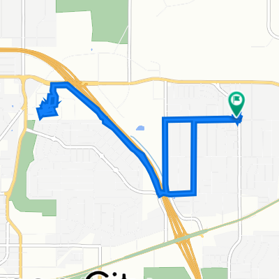
Route in Carson City
A cycling route starting in Carson City, Nevada, United States.
Overview
About this route
- 18 min
- Duration
- 5.1 km
- Distance
- 202 m
- Ascent
- 38 m
- Descent
- 16.8 km/h
- Avg. speed
- 1,668 m
- Max. altitude
Route quality
Waytypes & surfaces along the route
Waytypes
Quiet road
1.9 km
(38 %)
Road
1.7 km
(34 %)
Cycleway
1.4 km
(28 %)
Continue with Bikemap
Use, edit, or download this cycling route
You would like to ride Route in Carson City or customize it for your own trip? Here is what you can do with this Bikemap route:
Free features
- Save this route as favorite or in collections
- Copy & plan your own version of this route
- Sync your route with Garmin or Wahoo
Premium features
Free trial for 3 days, or one-time payment. More about Bikemap Premium.
- Navigate this route on iOS & Android
- Export a GPX / KML file of this route
- Create your custom printout (try it for free)
- Download this route for offline navigation
Discover more Premium features.
Get Bikemap PremiumFrom our community
Other popular routes starting in Carson City
 PrisonHillOddessyRiverViewTimberline
- Distance
- 51.2 km
- Ascent
- 718 m
- Descent
- 721 m
- Location
- Carson City, Nevada, United States
 Carson to Murwood
- Distance
- 49.6 km
- Ascent
- 341 m
- Descent
- 381 m
- Location
- Carson City, Nevada, United States
 washoe lake
- Distance
- 33.1 km
- Ascent
- 123 m
- Descent
- 116 m
- Location
- Carson City, Nevada, United States
 Cirque de Carson (Intermediate single track, and wider)
- Distance
- 52.1 km
- Ascent
- 625 m
- Descent
- 627 m
- Location
- Carson City, Nevada, United States
 Dia 5 - Bajada a Sacramento
- Distance
- 281.5 km
- Ascent
- 1,155 m
- Descent
- 2,577 m
- Location
- Carson City, Nevada, United States
 904 S Minnesota St, Carson City to 21 Milliman Way, Carson City
- Distance
- 8.8 km
- Ascent
- 63 m
- Descent
- 74 m
- Location
- Carson City, Nevada, United States
 Airport Road 3250, Carson City to Airport Road 3250, Carson City
- Distance
- 9.9 km
- Ascent
- 22 m
- Descent
- 25 m
- Location
- Carson City, Nevada, United States
 Fairview Drive 1501, Carson City to South Edmonds Drive 4929, Carson City
- Distance
- 3.6 km
- Ascent
- 28 m
- Descent
- 0 m
- Location
- Carson City, Nevada, United States
Open it in the app