
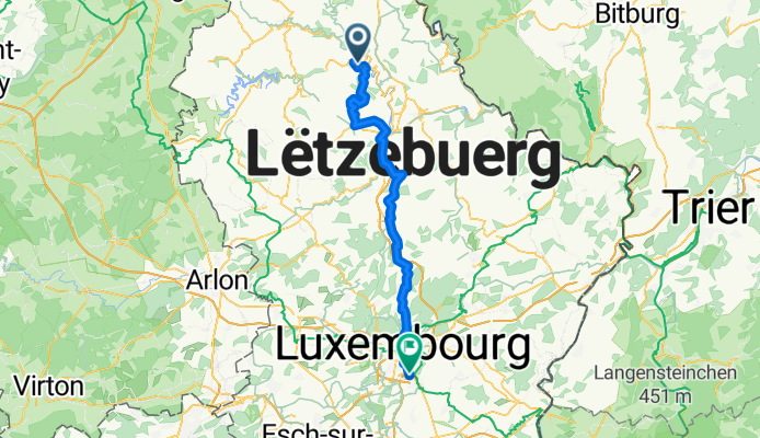
Route to Howald
A cycling route starting in Bourscheid, District de Diekirch, Luxembourg.
Overview
About this route
- 3 h 44 min
- Duration
- 61.3 km
- Distance
- 1,113 m
- Ascent
- 1,076 m
- Descent
- 16.4 km/h
- Avg. speed
- 473 m
- Max. altitude

Route quality
Waytypes & surfaces along the route
Waytypes
Quiet road
27.6 km
(45 %)
Cycleway
15.3 km
(25 %)
Surfaces
Paved
58.9 km
(96 %)
Asphalt
55.2 km
(90 %)
Concrete
3.7 km
(6 %)
Undefined
2.5 km
(4 %)
Continue with Bikemap
Use, edit, or download this cycling route
You would like to ride Route to Howald or customize it for your own trip? Here is what you can do with this Bikemap route:
Free features
- Save this route as favorite or in collections
- Copy & plan your own version of this route
- Sync your route with Garmin or Wahoo
Premium features
Free trial for 3 days, or one-time payment. More about Bikemap Premium.
- Navigate this route on iOS & Android
- Export a GPX / KML file of this route
- Create your custom printout (try it for free)
- Download this route for offline navigation
Discover more Premium features.
Get Bikemap PremiumFrom our community
Other popular routes starting in Bourscheid
 Lisseneck 4, Parc Housen to Lisseneck 4, Parc Housen
- Distance
- 23.7 km
- Ascent
- 912 m
- Descent
- 1,075 m
- Location
- Bourscheid, District de Diekirch, Luxembourg
 Hoscheid /ViandenVerkenningsritje 40 km
- Distance
- 40.7 km
- Ascent
- 556 m
- Descent
- 551 m
- Location
- Bourscheid, District de Diekirch, Luxembourg
 Bourscheid-Bourscheid Flèche du Sud 2015
- Distance
- 22.7 km
- Ascent
- 537 m
- Descent
- 542 m
- Location
- Bourscheid, District de Diekirch, Luxembourg
 Uewersauer Tour (A) 29/07-30/07 - Vëlosummer 2023
- Distance
- 19.4 km
- Ascent
- 550 m
- Descent
- 451 m
- Location
- Bourscheid, District de Diekirch, Luxembourg
 Leweck-Stadtbredimus
- Distance
- 86.7 km
- Ascent
- 393 m
- Descent
- 680 m
- Location
- Bourscheid, District de Diekirch, Luxembourg
 XBH - recon part b
- Distance
- 68.9 km
- Ascent
- 2,104 m
- Descent
- 2,020 m
- Location
- Bourscheid, District de Diekirch, Luxembourg
 Hoscheid Parc Naturel de l'Our 70 km
- Distance
- 71.4 km
- Ascent
- 1,014 m
- Descent
- 1,014 m
- Location
- Bourscheid, District de Diekirch, Luxembourg
 bourscheid II
- Distance
- 14.3 km
- Ascent
- 555 m
- Descent
- 566 m
- Location
- Bourscheid, District de Diekirch, Luxembourg
Open it in the app