

Wikiloc - 1.Chave -Regua - 1.Chave -Regua
A cycling route starting in Chaves, Vila Real District, Portugal.
Overview
About this route
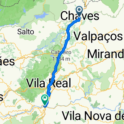
Route from Chaves to Juncal de Cima passing by :- Igreja dê Nossa Senhora da Conceição in Vidago (18.7 km) - Pedras Salgadas (30.1 km) - Fontanário do Carril (46.8 km)
- -:--
- Duration
- 96.4 km
- Distance
- 1,648 m
- Ascent
- 1,932 m
- Descent
- ---
- Avg. speed
- 735 m
- Max. altitude

Continue with Bikemap
Use, edit, or download this cycling route
You would like to ride Wikiloc - 1.Chave -Regua - 1.Chave -Regua or customize it for your own trip? Here is what you can do with this Bikemap route:
Free features
- Save this route as favorite or in collections
- Copy & plan your own version of this route
- Split it into stages to create a multi-day tour
- Sync your route with Garmin or Wahoo
Premium features
Free trial for 3 days, or one-time payment. More about Bikemap Premium.
- Navigate this route on iOS & Android
- Export a GPX / KML file of this route
- Create your custom printout (try it for free)
- Download this route for offline navigation
Discover more Premium features.
Get Bikemap PremiumFrom our community
Other popular routes starting in Chaves
 Chaves Régua pelas linhas do Comboio
- Distance
- 98.1 km
- Ascent
- 525 m
- Descent
- 823 m
- Location
- Chaves, Vila Real District, Portugal
 rota 3 santuários
- Distance
- 45.1 km
- Ascent
- 941 m
- Descent
- 943 m
- Location
- Chaves, Vila Real District, Portugal
 Bom dia!!
- Distance
- 36.8 km
- Ascent
- 790 m
- Descent
- 792 m
- Location
- Chaves, Vila Real District, Portugal
 Vidago-Xinzo de Limia
- Distance
- 85.3 km
- Ascent
- 387 m
- Descent
- 399 m
- Location
- Chaves, Vila Real District, Portugal
 Wikiloc - Von Chaves bis Peso da Régua - Von Chaves bis Peso da Régua
- Distance
- 103.6 km
- Ascent
- 2,307 m
- Descent
- 2,593 m
- Location
- Chaves, Vila Real District, Portugal
 Wikiloc - 1.Chave -Regua - 1.Chave -Regua
- Distance
- 96.4 km
- Ascent
- 1,648 m
- Descent
- 1,932 m
- Location
- Chaves, Vila Real District, Portugal
 teste
teste- Distance
- 54.9 km
- Ascent
- 869 m
- Descent
- 857 m
- Location
- Chaves, Vila Real District, Portugal
 1. Chaves- Régua bahn Route
- Distance
- 95.6 km
- Ascent
- 1,899 m
- Descent
- 2,191 m
- Location
- Chaves, Vila Real District, Portugal
Open it in the app